


Readers should be aware that both Khor Kharfot and Wadi Sayq are now protected sites under Omani law. Neither area can be visited without a permit issued by the government of Oman. They are not accessible by road at any point. Please contact the author if further clarification is needed.
Abstract: In May 2022, George Potter published an article that makes the most comprehensive case to date that Khor Rori in southern Oman is the most likely location for the place “Bountiful” described by Nephi. However, despite its many positives, there are a number of reasons to question the suitability of Khor Rori and to favor the other major candidate for Bountiful, Khor Kharfot. I propose that a careful reading of Nephi’s account coupled with recent discoveries based on field work show Khor Kharfot to be a superior candidate meeting all criteria we can extract from the text. To support a thorough comparison, aspects of both candidates are weighed, including pictorial comparisons of key features. I am in full agreement with Potter that with the entire eastern coast of Arabia now explored, only two candidates for Bountiful remain in contention — Khor Rori and Khor Kharfot. No other location still merits serious consideration.
In Nephi’s account of his family’s journey from Jerusalem to the Promised Land in the New World, one location plays a particularly prominent role. Nephi names this location Bountiful (1 Nephi 18:1), and it has been the quest of several individuals (including myself) to determine the real-world location of Bountiful. Following extensive exploration, there are two candidates for this location — Khor Rori and Khor Kharfot. I have been the chief proponent of the latter location, while George Potter has been the proponent of the former. Both locations are located in southern Oman, a region that fits comfortably with the Nephi’s account of travel and locations along Lehi’s Trail, as roughly shown in Figure 1. The numbered locations in Figure 1 correspond to: 1) three days of travel (from the borders of the Red Sea) to the Valley of Lemuel; 2) travel in a “nearly south-southeast direction”; 3) four days of travel to Shazer; 4) “many days” travel in the “same direction”; 5) mountains near the Red Sea; 6) “many days”; 7) “nearly the same course”; 8) at or near Nahom; and 9) “nearly eastward” to Bountiful.
[Page 220]
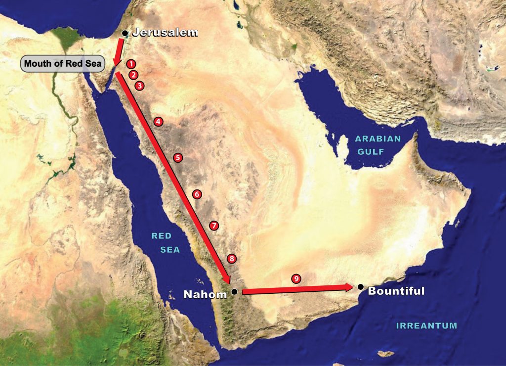
Figure 1. The basic parameters of the entire Old World Lehite land journey.
Khor Rori, a site in southern Oman that is the subject of Potter’s recent article advocating it as a candidate for Bountiful,1 is a fascinating place of great beauty, with one view provided in Figure 2. Since my first visit there in 1987, I have visited often over the years, watching the progress of the ongoing excavations and restoration of the fortress city of Sumhurum that sits above the bay. No one doubts the historical significance of Khor Rori, especially in its role in trade since the late first century bc. I have explored the area many times — the ruins, the bay and its cliffs, and particularly its access wadi, Wadi Darbat, with its waterfalls, small lake, and rivers in the upper reach of the wadi.
While Khor Kharfot is also a fascinating place, its beauty and features are of a different kind. See, for example, the view from Google Earth provided in Figure 3 and the photograph in Figure 4. It is isolated by its surrounding terrain, today being accessed mostly by sea. The only land access is through Wadi Sayq, which leads through the steep Qamar mountains to the desert plateau; its beginning now lies in a restricted area at the Yemen border eastwards of Nahom. The inlet mouth of the wadi that is named Khor Kharfot is uniquely pristine and undeveloped, allowing a wide range of fauna and flora, including large trees, to remain within a distinctively fertile coastal area that extends several kilometers in either direction. While uninhabited today, its numerous human traces establish that people have lived here intermittently since the Neolithic period.
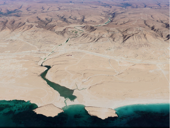
Figure 2. Google Earth view of Khor Rori and its access wadi, Wadi Darbat, facing northwards. Taken January 14, 2020,https://earth.google.com/web/@17.04826069, 54.44055207,37.67282052a,5699.32273148d,35y,0.00002243h,68.5200663t,-0r.
Figure 3. Google Earth view of Khor Kharfot and its access wadi, Wadi Sayq, facing west. This image of Khor Kharfot, taken September 1, 2020, followed a cyclone event that temporarily created two fingers of the lagoon just behind the beach. See https://earth.google.com/web/@16.73196485, 53.33227915,8.05873828a,1351.97913069d,35y,-80.33533324h,81.50555784t,0r.
[Page 222]
Figure 4. This view of Khor Kharfot facing southwest has been used in numerous publications, including the Encyclopedia of Mormonism, to represent the Old World Bountiful.
[Page 223]Strictly by the Book: Nephi's Descriptors of Bountiful
Readers should be aware that the subject of this essay, the Old World Bountiful, is emphatically not merely a debate of academic interest between two members of a small group of aficionados of Book of Mormon geography. Establishing the plausibility of the real-world location of Nephi’s Bountiful is fundamental — increasingly so as time passes — for the Book of Mormon to be taken seriously as a genuinely ancient account. Indeed, from its publication until recent decades, the description of a lush place of fruit and timber in Arabia was regularly considered an obvious Achilles’ heel of the entire Book of Mormon, along with the notion of an ancient book recorded on gold plates.
With that in mind, it is interesting to ponder why Nephi, with his overarching spiritual objectives and practicalities such as the limited space on the plates, gave us so much information about Bountiful, the place where his family ended their long trek from Jerusalem and where he built his ship. Significantly, those details were left intact centuries later when Mormon edited the earlier writings. Based on my research, I believe that no other location in the entire Book of Mormon has such a level of descriptive detail recorded, not even such pivotal Old-World locations as the Valley of Lemuel, Shazer, and Nahom, and New-World locations such as Zarahemla and Cumorah.
Whether Nephi was prompted to record this documentation to one day provide a means to establish the credibility of the record, his evocative yet matter-of-fact depiction of the place has fascinated readers of his narrative since it was first published. His text seemed wildly implausible in many particulars when judged against what was known about the Arabian Peninsula in 1830. Accurate information about Arabia providing plausibility for the claims took more than a century to begin becoming available; that process continues in 2023.2
Over the years, believing readers of Nephi’s account, trying to reconcile his description with their knowledge of Arabia, have proposed a number of possible real-world locations for Bountiful. These have ranged from Aden in Yemen at the southernmost point of the Arabian Peninsula to Qurm Kalba in Sharjah, the United Arab Emirates, just outside of northern Oman. As satellite imaging became more accessible in the late twentieth century, it became possible to make more informed proposals, and, eventually, conditions allowed exploration on the ground. The one-day visit to southern Oman by Lynn and Hope Hilton in 1976 and my own explorations from 1987 onwards were very preliminary beginnings but clearly revealed the path ahead.
[Page 224]Conditions did not allow the Hiltons to visit outside the immediate area of the capital, Salalah, meaning that neither Khor Rori nor Khor Kharfot were visited. As related in their book, In Search of Lehi’s Trail, their visit to Oman followed a suggestion by Hugh Nibley; they concluded that the main aspects of Nephi’s Bountiful could be found in the wide Salalah bay. The section “Land Bountiful” in their book thus concluded that the main aspects of Nephi’s Bountiful could be found in the wide Salalah bay. That section of the book provided two images: a two-page spread of a beach sunset at Salalah with the cliffs of Raysut on the horizon3 and a small image of trees at one of the springs nearby.4 By the time of my first visit to Oman in 1987, I was aware of Khor Rori and went there soon after arrival, becoming the first Latter-day Saint to visit the place, as far as I know. Going there merely to see what I assumed must be the place Nephi’s ship was built, I was immediately perplexed to find that key features described in Nephi’s text were either widely scattered or missing. This led to a closer examination of his writing that resulted in the twelve requirements for Bountiful that I will discuss shortly. I began asking questions about what else might lie along the coast in both directions.
The way forward really came in 1992, at the completion of a four-year effort of land exploration of the entire east coast of Arabia, examining the terrain from Aden in Yemen eastwards to northern Oman.5 Most of the hundreds of kilometers of coast, often without road access, proved every bit as barren and forbidding as the popular stereotypes of Arabia. Nine coastal locations in Yemen and Oman — those having, as a logical minimum, access from the west and a fresh water source — were first identified, and I discovered that the presence of fresh water did not itself ensure vegetation. The majority of the places proved unimpressive because of poor soil quality. All locations were then compared to Nephi’s text. The only potential candidates that passed this closer scrutiny were in southern Dhofar, Oman, in an area next to the border of Yemen, where the annual monsoon from the Indian Ocean provides moisture that permits significant vegetation in suitable settings.
Since then, further exploration — initially hampered by difficult access — has reduced the possibilities to the two sites under discussion here. With the eastern Arabian coast now fully explored, no surprises await discovery: Nephi’s “Bountiful” seemingly must be one of these two locations — Khor Rori or Khor Kharfot.6
As already noted, Nephi’s description of the Old World Bountiful has no parallel anywhere in either the Old or New World accounts in the [Page 225]Book of Mormon. Combined with some logical requirements, his text distills into twelve requirements that form a vivid word-picture of a very particular place, one that remains at odds with the common perception of Arabia even today:
- Linked, directionally, to Nahom, the burial place of Ishmael.
- Terrain must allow feasible passage from Nahom to Bountiful.
- Must be on the coast and suitable for an encampment.
- Must have year-round fresh water.
- Must have plentiful food sources.
- May be part of a wider fertile area.
- Must be near a distinctive mountain.
- Must have oceanside cliffs.
- Must have timber suitable for shipbuilding.
- Must have ore suitable for creating tools.
- Little or no population.
- Favorable coastal conditions.
These twelve requirements are discussed in additional detail in the following sections.
Directionally Linked to Nahom
As the Lehites traveled in the wilderness, Ishmael died and was buried “in the place which was called Nahom” (1 Nephi 16:34). Nephi is very specific in recording the fact that from Nahom they traveled “nearly eastward from that time forth” (1 Nephi 17:1) until they arrived at the place where they built their ship. Thus, Bountiful lay “nearly” eastward of Nahom. Given that Nahom is now firmly correlated with the tribal district of Nihm in Yemen, this fact alone eliminates proposals on the central and southern coast of Yemen and any that lie on the central and northern Omani coast.7
Only the southern part of the Dhofar region of Oman — and nowhere else — can be considered “eastward” of Nahom. This can be stated quite unequivocally, as in the verse last quoted, Nephi used the same wording he had earlier used in describing the travel direction from the Valley of Lemuel (“nearly a south-southeast direction,” 1 Nephi 16:13, 14, 33). Nephi’s abilities in accurately determining variations from the cardinal directions means that Bountiful must lie close to Nahom’s 16th degree north latitude.
[Page 226]The correlation of southern Dhofar being “nearly eastward” of Nahom’s latitude (about 15.50 degrees north latitude) and also containing the only viable candidates for Bountiful (Khor Rori at 17.2 degrees N latitude, and Khor Kharfot at 16.44 degrees N latitude) has been one of most stunning developments yet in establishing the historicity of the Nephite scripture.
Suitable Terrain for Passage From Nahom to Bountiful
At some places along the Arabian coast, the terrain is so rugged that any overland travel from the interior is impossible. In such places, only a drainage wadi could provide a pathway to the coast. The low Qara ranges behind the Salalah bay, inland of Khor Rori, have multiple access wadis providing access to the ocean, but, paradoxically, the highest and most extensive mountain barriers are found along the Qamar coast, the westernmost section of southern Dhofar where Khor Kharfot is situated. In this area, therefore, a wadi route through these mountains is required.
Coastal Location Suitable for an Encampment
Bountiful was a coastal location (1 Nephi 17:5) suitable for an initial seashore encampment in tents (1 Nephi 17:6), but also with higher ground available for more substantial dwellings during the unavoidable months of rain, heavy seas, and annual monsoonal winds. Most importantly, the place had to offer a harbor — a suitable place for the construction and launching of a ship capable of carrying the group (1 Nephi 18:8).8 Although it can, and has, been done, large vessels are not easily constructed over a year or more on an exposed beach, subject to tidal surges and winds. In ancient times, the most practical solution was usually the shores of a sheltered inlet or lagoon that protected from tides and storms while still allowing ready access to the ocean.
Year-Round Fresh Water
Fresh water at the site is, of course, required by their stay of what was certainly several years. That fresh water was abundant is implicit in the description of the flora awaiting the Lehite group upon their arrival. Further, it was most likely readily accessible so that the ship construction could proceed without diverting significant energy and time to carrying water in from elsewhere.
[Page 227]Plentiful Food Sources
Nephi tells us twice that “Bountiful” was named specifically for its “much fruit” and also “wild honey” (1 Nephi 17: 5, 6). While unmentioned, other food resources not proscribed under Mosaic Law would certainly have included the abundant fish in the ocean and small game that could be hunted (1 Nephi 18:6).
It was much more than just a suitable place to build and launch a ship. As discussed shortly, the record very strongly indicates that Bountiful was uninhabited when Lehi arrived. If so, this requires that the fruit mentioned was not cultivated but grew wild. The Hebrew term for “fruit” normally refers to edible fruit, and despite being abundant, Nephi’s use of the singular “fruit” may imply that there was not necessarily a great variety of fruits. Historically, the “fruit” referred to in Nephi’s day was most likely fig, date, and tamarind, although others remain possible.
The apparent availability of fruit upon arrival may explain the lack of any mention of the group growing crops at Bountiful, unlike the description of their arrival in the New World (1 Nephi 18:24). However, some agricultural pursuits during the years of their stay at Bountiful are certain. As they still do today for the desert-dwelling Bedouin, the group’s camels could still provide hides and hair throughout their time at Bountiful. Camel meat, however, was prohibited by the law of Moses (Leviticus 11:4), and since the camel was considered unclean, the milk also would not be consumed.9
A Surrounding Fertile Land
Nephi’s use of “the land which we called Bountiful” (1 Nephi 17:5) and “the land Bountiful” (1 Nephi 17:7) suggests that a wider, more general area may have also enjoyed fertility in addition to the particular location where the Lehites initially camped (1 Nephi 17:6), thus making any candidate location for Bountiful without a comparable surrounding fertile area less likely.
Near a Distinctive Mountain
A mountain must be singular and distinctive enough that Nephi records the voice of the Lord telling him to go “into the mountain” (1 Nephi 17:7) before recording — using the same phraseology — that he did as directed and adding that he went “up” to do so. From this wording, the implication is clear that the mountain needed no further identification or explanation by the Lord. Nephi’s later, third, mention of the mountain retains the same wording of going “into the mount,” expanding it to note [Page 228]that he went there to “pray oft” (1 Nephi 18:3), thus requiring that the mountain was close enough to the coastal encampment to access often.
In all three instances, the wording of going into the mount (rather than “onto,” “upon,” or “up to” it) is used. This may signify that Nephi did not necessarily climb to the summit of the mountain, instead perhaps using the privacy of an accessible but still elevated location on its slopes, such as a recess or cave for his frequent communications with the Lord.10
Oceanside Cliffs
The incident of Nephi’s brothers attempting to take his life by throwing him into the depths of the sea (1 Nephi 17:48) makes no logical sense unless there were substantial cliffs overlooking the ocean from which to throw him. Oceanside cliffs typically have rocks at their base from erosion and would constitute a real danger to anyone falling on them from a height, whereas a beach without cliffs would not pose any danger, especially for a young man who is described as being “large in stature” (1 Nephi 2:16) and “having much strength” (1 Nephi 4:31).
Timber for Shipbuilding
Any candidate for the site of Bountiful must have enough shipbuilding timber of types and sizes to permit building a vessel able to carry several dozen persons and remain seaworthy for at least a year (1 Nephi 18:1-2). Note that Nephi did not ask where to locate timber, only ore to make tools, which strongly implies that timber was readily available but not the tools needed to fashion that timber into a ship.
Ore for Making Tools
Ore, from which metal could be smelted to construct tools, was available in the vicinity (1 Nephi 17:9–11, 16), perhaps with some type of flint (1 Nephi 17: 11). By choosing the term “ore” it seems likely that Nephi, whose expertise in metalsmithing is clear throughout the record,11 left the specifics to the Lord in his request for guidance to make the tools necessary for working with wood. While it remains probable that he carried some type of flint with him to make fire, his wording might imply that flint was also available at, or near, the location of the ore source. Iron is the most likely metal utilized by Nephi for tools.
Little or No Population
Very importantly, despite the attractiveness of the place, 1 Nephi 17 is full of indications that Bountiful had little or no resident population at[Page 229] that time who could contribute tools and manpower to the ship building process. Consider that rather than simply consulting locals or making a local purchase, it required a specific revelation to show Nephi where ore could be found (1 Nephi 17:9–10) to make basic tools. Great effort was then expended by him to fashion his own bellows of skins, locate the ore, make fire by striking stones together, smelt it and then manufacture the tools he would need. Such items as basic tools, bellows, and a fire source would have been easily obtained by anyone living in or near a populated seaport.
It is also clear from the record that Nephi needed the labor of his brothers and of Zoram, whereas a populated location would likely offer other, more willing, sources of labor.
Of course, Lehi could also easily have been directed to bring sufficient portable wealth from his estate in Jerusalem to simply purchase an entire ship, or commission the building of one had the group been headed for a shipbuilding area. While one could argue that the shipbuilding stage was part of their preparation for the New World, the group had already faced many years of difficult travel dominated by hunger and privation. The more likely reason that they had to construct their own ship is that no vessels in that part of the world were adequate for a journey of the magnitude required.
The frequently dissenting Laman and Lemuel left Bountiful readily enough on a long and dangerous sea voyage, surely their first time on the open sea, when the time came. This very strongly suggests that there was little at Bountiful to distract them from assisting Nephi in building the ship or to entice them to remain. I suspect that years of encounters with mostly Arab peoples on their journey would have broadened their cultural outlook. Had they been living for some time in or near a thriving port, commercial opportunities for wealth would surely have appealed after years of desert privation. Furthermore, had Bountiful been in or near a trading center, with ships and camel caravans coming and going, that would have given them an easy opportunity to return to their beloved Jerusalem.
After arriving in the New World, Lehi learned by revelation that Jerusalem had been destroyed (2 Nephi 1:4). Although precise dating of the destruction and of the Nephite departure from Bountiful remains unclear, it is very possible the destruction took place while the Lehites were still at Bountiful. If so, it is significant that Lehi learned of it by revelation, not from locals at Bountiful who would have known this momentous news from arriving travelers within months of it happening.
[Page 230]It also seems unlikely that Lehi’s group, at such a critical juncture in their journey, would have been intended to settle for years where they would be exposed to the distractions and pagan beliefs then prevalent in Arabia. Rather, the place “prepared” of the Lord may have been intended to keep them apart from other people for that very reason.
Favorable Coastal Conditions
Finally, coastal conditions had to include ready access to the open ocean and to suitable winds and currents (1 Nephi 18:8–9) that could carry Nephi’s ship toward the New World. The ship would have landed along the Pacific coast, as Alma 22:28 seems to stipulate when it mentions that the west coast of the land was the place of “first inheritance.” It remains true that the west coast of the Americas can be reached by sailing below the African and South American continents, but many researchers, including this writer, prefer the less dangerous option of a voyage eastward across the milder latitudes of the Indian and Pacific oceans.12 Sailing east from the Indian Ocean onwards is normally problematic as the prevailing winds and currents are in the opposite direction, but in recent decades we have learned that ENSO weather events13 regularly facilitate such travel.
Contrasting Khor Rori and Khor Kharfot: Toward Resolution
Both the Khor Rori and Khor Kharfot sites meet the two logical candidate requirements — that is, the logistical necessity of having terrain allowing travelers to reach the coast from the interior desert, and both having fresh water available year-round. The locations are near each other, as shown in Figure 5.
It should be noted, though, that in his writings, Potter assumes that the Lehite land journey across Arabia essentially used the trade route in reverse, including the final leg from Nahom to Bountiful.14 However, there is no evidence that an established eastward trail from Nahom ever existed or was used. Instead, from the region of Nahom the main trade route veered southeast toward Marib, then east toward the main transit point for trade at Shabwah, and ultimately southeast again to the port of Bir Ali on the coast, as shown in Figure 6. The only established route to Dhofar was from Shabwah (not directly from Nahom) going northeast to the small desert caravanserai of Shisr, often speculatively called “Ubar,” and only then southwards to Wadi Darbat and Khor Rori.15 Compared to the plausible eastward route to Khor Kharfot as shown in Figure 5, the southward and northward bends proposed by Potter, though not [Page 231]ruled out, are not as clearly consistent with Nephi’s indication that they traveled “nearly eastward” (1 Nephi 17:1) after departing Nahom.
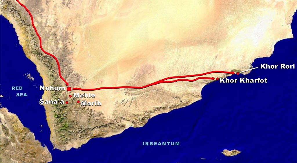
Figure 5. Map of possible routes from Nahom to Bountiful based upon Nephi’s statement that the travel direction from Nahom was “nearly eastward from that time forth” (1 Nephi 17:1). As shown, the route to Khor Kharfot is slightly nearer to true east than the route to Khor Rori, which trends a little more to the north.
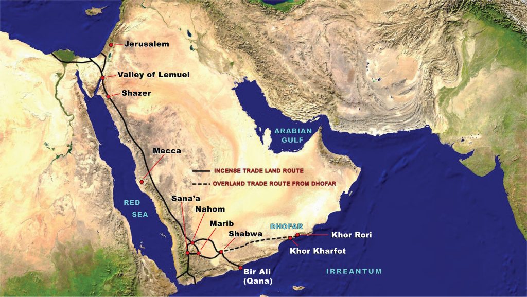
Figure 6. A simplified map using solid black lines to show the major overland trade routes (which operated in both directions).
While there is no doubt whatsoever that the Lehite group used, perhaps for long stretches, sections of trade routes, so far as the final stage of the journey — from Nahom to Bountiful — is concerned, Nephi’s account describes anything but a well-worn trade route with its varied directions and regularly spaced water sources as the Potter scenario [Page 232]posits. Having traversed the interior areas eastwards of Nahom more than once, I have likely experienced first-hand some of the underlying reasons (generally zero water sources, isolation, lawlessness, etc.) why Nephi graphically described this final leg as the most difficult of their entire journey (1 Nephi 17: 1–5). As satellite imagery and any map will show, even in modern times, the region north of Marib and extending east to Dhofar remains devoid of waterholes and settlements of any consequence, and has almost no roads.
That aside, both places share several of the “Textual Indicators” specified in Nephi’s record. They are both coastal locations that can be considered “nearly eastward” of Nahom, both have local wild honey sources and high cliffs. Both also have ore sources, iron in both cases, over 30 km (18 miles) from Khor Rori at Mirbat, and less than a half kilometer (a third of a mile) from the seafront at Khor Kharfot.16
Most importantly, both places are suitable for ship construction and have a harbor to access the ocean. Potter downplays the inlet at Khor Kharfot by critiquing the accuracy of a painting that I commissioned several years ago (see Figure 7) showing what the geological and historical features tell us about the place two and a half millennia ago.
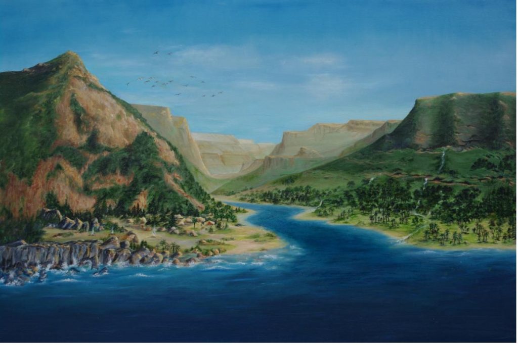
Figure 7. A depiction of what Khor Kharfot may have looked like ca. 600 BC. While Khor Kharfot is a smaller inlet, construction of a “ship” and launching it into the ocean is entirely possible in this setting.
Potter writes, “Although today there is no inlet at Khor Kharfot, Aston has presented an illustration showing what a harbor might have [Page 233]looked like in Lehi’s time.”17 A sand barrier today usually does block the inlet at Khor Kharfot, as one does at Khor Rori itself and at other spots along the Omani coast, all believed to be relatively recent developments. However, I have myself experienced and documented an occasion when Khor Kharfot’s sand bar beach was opened to the ocean, just as Khor Rori’s sand bar opened to the ocean even more recently, as shown in Figure 8. Contrary to Potter’s critique, the painting does, in fact, present a completely plausible view of the ancient inlet at Khor Kharfot.
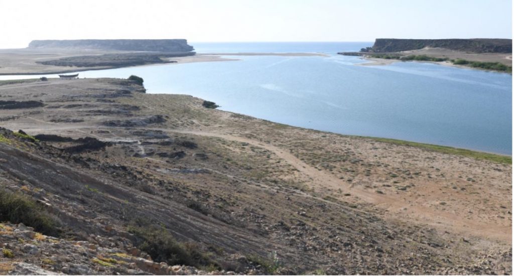
Figure 8. This general view from the ruins of Sumhurum looks towards the ocean across the large inlet at Khor Rori.
The topography in the painting is otherwise much as it appears today except that the western plateau at the base of the mountain is less eroded. Erosion has diminished its width over the centuries, evidenced by ruins on the western plateau that have collapsed since they were built. This plateau appears to be the most likely place for permanent settlement in accordance with archaeological findings over recent decades.
The recent view of the inlet at Khor Rori in Figure 8 is shown from the elevated Sumhurum ruins. Points of interest are the breach visible in the sand-bar beach across the inlet in the distance, leading to the open ocean, and the ship displayed in the upper-left representing a typical vessel known to be in use when this was a functioning port. The two promontories enclosing the sand bar, Inqitat Mirbat on the east (left) side and Inqitat Taqah on the west (right) side, are visible in the distance.
We should also at least briefly note that Khor Rori and Khor Kharfot are not the only harbor possibilities in Dhofar; quite a large harbor can still be seen at Al Balid, close to Salalah city. It was constructed directly next to the beach following the collapse of Khor Rori, becoming the [Page 234]only functioning harbor for the capitol from roughly the eighth to the sixteenth century ad.18
The differences between Khor Rori and Khor Kharfot, however, are vividly evident when we examine the remaining indicators: the availability of wild fruit, being part of a wider fertile area, accessible shipbuilding timber, a distinctive mountain nearby, and no resident population. As modern analogues of the past, these five aspects represent the greatest disparity between the two sites and will now be discussed. As far as possible, they are illustrated here by contrasting photographic views of them as they appear today. Care has been taken to display favorable views of each location, with images taken from 1987 to 2022.
Wild Fruit
The primary species that would have been considered “fruit” by the Lehites are figs (see Figure 9) and dates, while tamarind trees were also a valued commodity with multiple uses in that era. These species grow wild and abundantly at Khor Kharfot today.
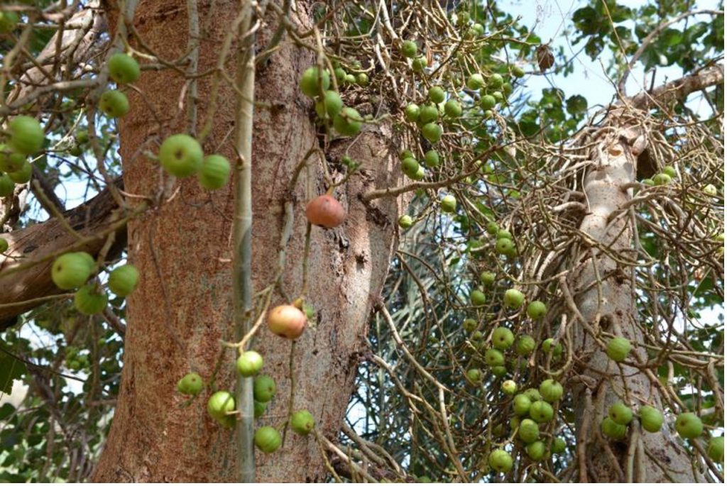
Figure 9. Wild fig trees at Khor Kharfot.
In contrast, visitors to the Salalah bay, including Khor Rori, encounter an area characterized by thin, overgrazed soils. However, they can certainly see “much fruit,” but it is primarily in the form of modern irrigated orchards and plantations, mostly growing commercial species of bananas, dates, coconuts, and citrus, all introduced to Oman [Page 235]in recent centuries. Recent studies suggest the possibility that date palms may have grown at Sumhurum at Khor Rori in the past, but note that it remains possible that the evidence for this may have been brought there by visiting traders.19 Dates do not grow naturally in the Salalah bay in modern times.
Aside from the cultivated plantations — which, it must be noted, are several kilometers from Khor Rori — the fig and tamarind trees that Nephi would be familiar with are found growing naturally only in some pockets of Wadi Darbat in the Qara hills, several kilometers inland from Khor Rori. This does not rule out Khor Rori on the basis of fruit, of course, but the abundance of natural fruit immediately present at Khor Kharfot is a relative advantage of that site.
The Land at Both Sites
There is a recent study of the geomorphology (the physical structure of an area and its soils, how it was formed and has evolved over time) of the Salalah region.20 While quite technical in nature, the paper has numerous representative images of the terrain, of Wadi Darbat, and of Khor Rori that can readily be understood. The data in the paper gives no reason to suppose that natural vegetation in the thin stony soils of the Salalah plain was noticeably more abundant 2,600 years ago. Only kilometers inland from the coast, in the upper part of Wadi Darbat and adjacent wadis, does anything approaching Khor Kharfot’s fertility survive.21
A comparable but more focused study, published in 2016, of Khor Kharfot’s setting in the Qamar mountains is also available.22 As with the previous report, the images throughout are informative.
Ancient Traces of the Name “Bountiful”?
As seen in his recent article at Interpreter, George Potter has embraced the claim of a Salalah historian of the Shahri tribe that the ancient biblical tribe of Ophir settled in the Salalah area, specifically at Wadi Darbat and Khor Rori, giving their name to the harbor there.23 The significance he points out is that Ophir can mean “abundance” or “fruitful,”24 thus correlating with Nephi’s statement that Bountiful was so named “because of its much fruit and also wild honey” (1 Nephi 17:5, 6).
Regardless of the merits of this claim from the Old Testament period, what is surely a stronger case can be made with Khor Kharfot’s name, which derives from kharifot in the local Mehri (or Mahri) language. It is thus very old and predates even the arrival of the Arabic language, but still occasionally appears on maps and satellite images of the [Page 236]Kharfot area and nowhere else in Arabia. So, it is exciting to discover that kharifot actually may have dual meanings that relate to abundance and fruit: first, a link to the annual monsoon rains that make Khor Kharfot the most naturally fertile location on the Arabian coast, and second, the concept of ripe fruit.
In particular, kharifot comes from the Mehri root xrf > xérf “to produce fruit”; xarf “summer; rainy period, period of monsoon rains (mid-June to early Sept)”; šexāref “to collect ripe fruit”; and is an abstract noun ending in -ot. In related pre-Arabic languages from the region it has similar derivations: see Socotri (or Soqotri, a language spoken near the Horn of Africa in the Socotra Archipelago) xōrf “harvest” and Ḥarsūsi (spoken in a remote region in south-central Oman) xōref “autumn.”25 There is also an etymological link between kharifot and khareef, the common Arabic term for the monsoon rains in light of ḫarif (خريف) “autumn, fall; monsoon-season” and ḫarifi (خريفوي) “autumnal.”26 When the –ot or –ut ending (signifying an abstract quality) is added, the term ḫarifot (خريفوت) results.27 The etymological connections make Khor Kharfot and kharifot an excellent match for the name Bountiful.
A further potential historical link to the Book of Mormon account survives in the origin accounts preserved by the Maya people of southern Mexico and Central America. Their records indicate that their ancestors left from Tulan, or a “place of abundance” that lay to the west, far across the oceans. For example, several Guatemalan documents detail ancient Mesoamerica legends about coming from a distant “Lugar de la Abundancia” (“place of abundance”).28 While Spaniards translated Tulan as “Lugar de la Abundancia,” in recording the myths, the term derives from a Nahuatl word referring to a “place of reeds” or “place of cattails [or bullrushes]”29 which also provides a significant clue to the identity of this place. Very early on, it seems, Tulan became almost ubiquitous in the early accounts of origins and over time came to be associated with their creation legends. What is relevant here is the simple fact that branches of the Maya claim that their forbears came from a unique place, one with characteristics striking enough to be remembered in detail in their foundational accounts over a thousand years later.30
A Wider Fertile Area
Figure 10, showing the aridity near the stream of Wadi Darbat as it approaches Khor Rori, should be considered with the satellite overview presented earlier in Figure 2. These images, when compared to photographs from Khor Kharfot, speak eloquently of the contrast [Page 237]between the two settings. Khor Rori is an almost barren plain with natural vegetation present only several kilometers inland in the upper wadis.
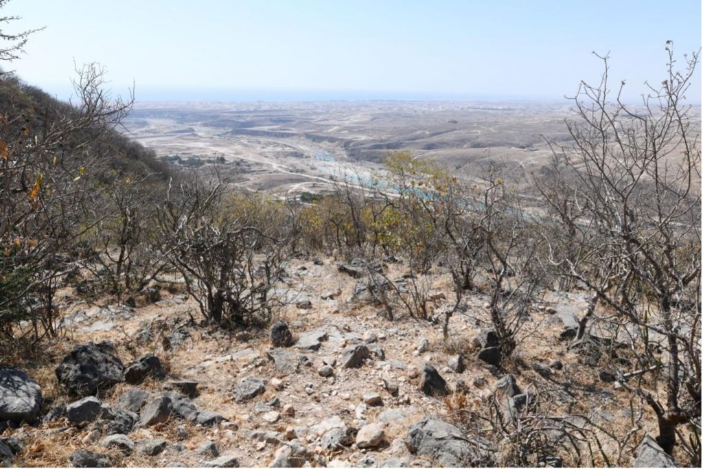
Figure 10. A general view facing southwards shows the stream of Wadi Darbat flowing over the Salalah plain towards Khor Rori at the coast.
Khor Kharfot, on the other hand, sits near the eastern end of a belt of extensive vegetation extending a total of over 60 km (over 37 miles) of atypically fertile terrain, all of it at, or very near, the coast.31 Figure 11 is typical of the surrounding area.
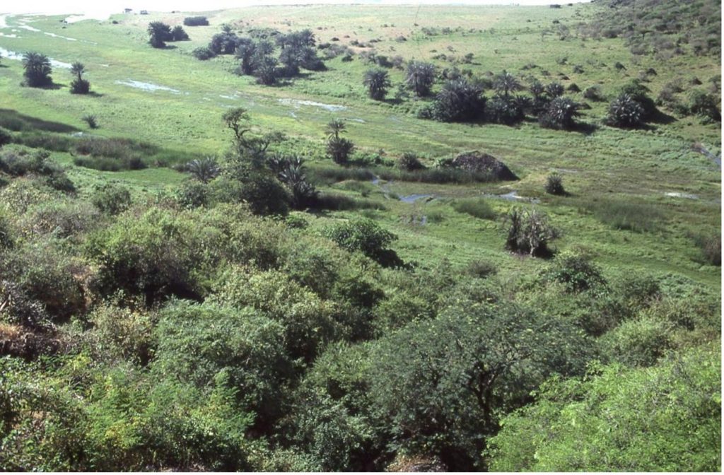
Figure 11. A general view facing southwards across Khor Kharfot’s bay, just inland of the freshwater lagoon.
Timber and Shipbuilding
The culmination of Lehi and Sariah’s epic Old World journey from Jerusalem to Bountiful is the building of a ship under Nephi’s direction that conveys the group many thousands of kilometers to the Americas. This pinnacle in the saga — the ship and its long ocean voyage — is complex and cannot be dealt with simply or quickly; a full treatment would fill several books. What follows is, at best, a summary with links to more detailed sources.
Potter expresses concern that the trees at Khor Kharfot are inadequate for shipbuilding and includes an image of a small “gnarly” fig tree.32 It might have been better if Potter, who visited Khor Kharfot in 2011, had used images of large trees that are actually at the site (see Figure 12) and even large trees growing inland of his own site candidate, Khor Rori (Figure 13).
[Page 238]
As can be readily seen, there indisputably are large timber trees growing today at Khor Kharfot, and also inland of Khor Rori. The question then becomes: assuming Nephi built a hulled vessel, is the timber from these species suitable for shipbuilding?
There still exists a common misunderstanding that early Arabia lacked useful wood and relied on imported timber. Much more was available than we usually realize, however. After reviewing a range of tree species in Arabia and their uses, one authority stated with specific reference to ship construction:
The presence of these wood resources in the Arabian landscape mitigates the general misconception in boat-building studies that the Arabian peninsula was bare of trees and reliant on imported timber for boat-building.33
While teak was imported from India for shipbuilding in northern Oman since about the third millennium bc, the clear scriptural implication seems to be that the place “prepared of the Lord” for the Lehite group had all the materials needed for the ship without recourse to obtaining timber from elsewhere. The wording of 1 Nephi 18:1 (we “did go forth … and we did work timbers of curious workmanship”) conveys the impression that the timber was at hand. It is also worth noting that [Page 240]Nephi uses the plural whenever timber is mentioned, suggesting that more than one type of wood was involved, as is usual in shipbuilding.
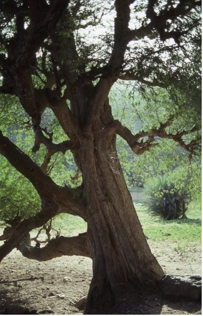
Figure 12. One of numerous large Tamarindus indica and Ficus sycomorus trees growing at Khor Kharfot.
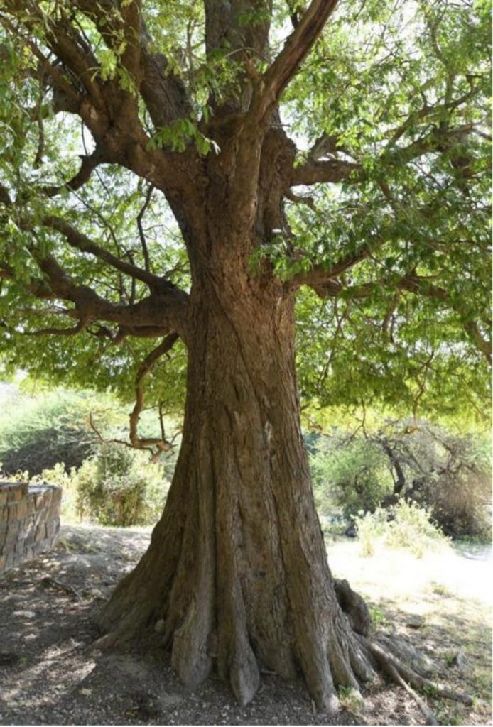
Figure 13. Inland and east from Khor Rori, a tamarind tree growing at Wadi Sha’boon. Image taken 2022.
While almost every commentator describes the preferred timber for ship hulls in the Indian Ocean as teak it was very often (and eventually mostly) another timber, Artocarpus hirsutus, commonly known as “aini” [Page 241]or “wild jack” from India, that was often used to build conventional ships. It was actually superior to teak in several ways — more durable, more resistant to ship worms, and less expensive. The oft-cited 1980–1981 “Sindbad” voyage of the sewn “Sohar” ship from Oman to China used this timber for the hull, not teak.34
A Closer Look at Tamarind Timber
While it is true that the tamarind timber that is still available at both Khor Rori and Khor Kharfot does not figure prominently in shipbuilding, most people are unaware that the heartwood of this species is classified as a “hard wood.” Tamarind trees grow to about 24 meters (80 feet) tall and are understood to have arrived in Arabia from Africa in ancient times. The timber, “prized for its strength and termite resistance … is hard and durable,” and was used in ancient Sri Lanka for “side planks for boat[s].”35
Its use is attested for boatbuilding in parts of Africa.36 Plus, tamarind is one of the timbers being used to build Ceiba, the world’s largest all-wooden sailing cargo ship, in Costa Rica, due for completion and launching sometime in 2023 according to the latest report (see Figure 14).37
Tamarind, properly caulked and perhaps treated with a sealant made from local materials, may yet prove to be a resource Nephi used to build his ship. However, at this point in our understanding of timber assets that may have been available to him in both the Qara and Qamar regions of Dhofar, I prefer to remain open to all possibilities for his ship, both as to the wood used and the design. Caution is surely warranted when we examine two assertions by Nephi, as discussed in the following sections.
Curious Workmanship
Nephi’s phrase that “we did work timbers of curious workmanship” (1 Nephi 18:1) has generated a lot of attention by commentators over the years. Those who believe that the Old World Bountiful “prepared of the Lord” nevertheless lacked suitable shipbuilding timber 2600 years ago suggest that the word “curious” must mean that that the family did not log local timber, but used wood imported from India that was “pre-cut in an unfamiliar manner.”38
The word curious itself has several common meanings besides the ones most used today. Rather than meaning “unusual” or “inquisitive” as it does in modern English, in Joseph Smith’s era it also refers to anything “made or prepared skillfully,” “done with painstaking accuracy or attention to detail,” and “careful; fastidious.”39 Hagoth, the Nephite [Page 242]shipbuilder (Alma 63:5–8), was said to be “an exceedingly curious man,” meaning “wrought with care and art; elegant; neat; finished.”40
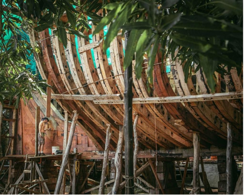
Figure 14. The huge all-timber ship, Ceiba, being completed in Costa Rica, uses a local variety of tamarind timber (Tamarindo del Monte) in its construction. Image courtesy of the Sail Cargo project.
Rather than reading the text in a modern sense (i.e., that Nephi worked timbers in an unusual way, or that the timbers were themselves somehow unusual), the modern reader should understand that Nephi seems to have been stating that the timbers were worked in a careful and skillful way, just as he had earlier referred to the Liahona as a “round ball of curious workmanship” (1 Nephi 16:10). We should not overlook the fact that, if nowhere else, Nephi and his family quite possibly would have had opportunities on their journey while at the Red Sea to observe various vessels, enabling them to recognize that the ship they were constructing differed from the ships of their day.
Combined with the fact that the building of the ship required revelatory guidance “from time to time” (1 Nephi 18:1, 3), Nephi’s comments link this guidance to the working of the “timbers” (1 Nephi 18:1, 2) in particular, and apparently also the manner of the ships building (1 Nephi 18:2), perhaps necessitated by the vessel’s design. Both [Page 243]aspects thus differed from other ships they knew. At a minimum, they required a long-distance ship rather than the purely local craft such as those they may have already seen.
Not After the Manner of Men
Some of the broad principles of shipbuilding and its history can yield insights into the task facing Nephi, his brothers, and Zoram.41 1 Nephi 18:2 tells us — twice — that the ship was not built after the “manner of men.”
Among the many possibilities raised in attempting to explain what the “manner of men” referred to, one is that Nephi was directed to reverse the shipbuilding technique of that era; instead of building the hull first and then adding the skeleton, perhaps he built the skeleton first, before adding the hull or “shell.” This is actually a technique that was not introduced until during the first millennium ad, allowing improvements to be made to ocean-going ships.42
Could Nephi Have Built Some Type of Raft or Catamaran?
Noting that I have previously raised the possibility that Nephi’s ship may have been some kind of a raft or catamaran, the Potter article charges me with a “dangerous supposition — that Joseph Smith made errors in his translation of the Book of Mormon” — and states that “the prophet certainly knew the difference between a ship and a raft.”43 However, I have never stated that I believe Nephi’s ship was a raft. The possibility has been raised only to make the point that we must not confine ourselves to narrow definitions of what a “ship” might be.
I actually favor a mortise and tenon timber ship. But in a work translated from an ancient language, the word ship can refer to a wide variety of structures, and we must not assume we can infer details of the design or construction from a single word. We have no indication that the divine translation process gave Joseph detailed information beyond the English words of the text itself.44
Potter also downplays the abilities of rafts by stating that they lack the “capabilities” of ships and cannot be steered.45 Both assertions are factually wrong. Rafts can indeed be steered through a combination of sail adjustments, and centerboards are known to have done so for hundreds of years at least.46
In some respects, rafts are actually superior to conventional ships. For example, they can carry larger loads than hulled ships and are essentially sink-proof. Anthropologist and retired Master Chief Petty Officer, P. J. Capelotti, referring to the Kon Tiki raft voyage across the same ocean [Page 244]that the Lehites probably crossed, made a general point about the merits of rafts that will strike many Latter-day Saints as significant:
By its very structure, a raft is a floating warehouse. They were therefore the perfect vessel to carry the contents of a culture across an ocean. They are not fast, but they are virtually indestructible. If a conventional sailboat gets a small hole in its hull, it sinks. By contrast, a … raft can lose two thirds of its hull and still keep its crew and twenty tons of cargo afloat.47
In 1947, the raft that Heyerdahl is best remembered for, the balsa log Kon Tiki, sailed westward across the Pacific Ocean from Peru, reaching Tahiti in 101 days after covering some 6,900 km (4,300 miles). Potter notes that the Kon Tiki’s journey ended when it smashed into a reef but fails to mention that as the traditional raft design became better understood, numerous later voyages by Heyerdahl and others were, in fact, steered to safe arrivals regardless of wind direction. Almost 60 years after it took place, for example, the Kon Tiki voyage was repeated by a team that fittingly included a grandson of Heyerdahl, and the Tangaroa covered the same route in just 70 days before landing safely.48 That journey confirmed the efficacy of ancient steering methods, though these methods had not been properly understood by Heyerdahl, resulting in the crash.
Heyerdahl’s pioneering endeavors were the primary stimulus for dozens of other ventures using rafts to cross the Pacific, Atlantic, and Indian oceans, as well as shorter sailings in various parts of the world. Such efforts continue to the present, often learning new lessons that result in faster sailing times.
In 1973, the Las Balsas expedition set sail from Ecuador with three rafts. Each 14-meter-long (46-foot-long) raft consisted of seven balsa logs and maneuvered with the use of guayas, short centerboard planks between the logs. No metal was used in the construction. The design proved to be “very stable, with little roll” as they crossed the Pacific. After 179 days at sea and covering some 14,000 km (8,700 miles), the three rafts arrived together on the Australian coast, a distance record that still stands.49
Since we are dealing with something unique and “not made after the manner of men,” we would surely be wise to stick to the text and avoid judgments about the style of the ship. After all, in view of the capabilities and advantages of rafts noted earlier, if Nephi did build some kind of raft, he was in good company.
[Page 245]The Unknowns Regarding Timber at Both Locations
Leaving aside the other descriptors in Nephi’s text, the question of shipbuilding timber remains unresolved. This may be summarized as follows:
Firstly, both Khor Rori and Khor Kharfot have accessible native timber growing that would have been available to Nephi, either from the upper part of Wadi Darbat or an adjacent inland wadi in the case of Khor Rori, or at the water’s edge at Khor Kharfot. However, the suitability of the available tree species for use in shipbuilding is disputed by most commentators.
Pollen studies near Khor Rori and along the Qara coast have not revealed any timber species not currently growing in the area and, therefore, Potter’s support for Khor Rori relies on the possible importation of wood from India or possibly from Africa. Trade between India and Arabia, for thousands of years, has been well known for a long time.50 Potter cites studies that appear to support a shipping trade in timber to Khor Rori earlier than the third century bc, but they refer to northern Oman and the Arabian Gulf, over 1,000 km (600 miles) from Khor Rori and too distant to be available to Nephi.
He also mentions ruins that have been discovered on “Inqitat,” one of the two promontories enclosing the harbor area at Khor Rori, suggesting that they may evidence shipping earlier than is documented by the building of Sumhurum. In the first place, there are ruins on both of the promontories, properly named Inqitat Mirbat (on the east) and Inqitat Taqah (on the west). In both cases, the dating of the ruins remains unclear, although some of them might date as early as the fourth or eighth century bc, but they are regarded as the remains of fortresses built by “pastoral settlements” and include later burials from the Islamic period. There is nothing to suggest that anything more substantial — especially seafaring activities — is implied by them.51
Furthermore, well-established archaeology tells us that Khor Rori did not begin to function as a port until the end of the third century bc and the only evidence for trade by sea stems from that period — around three centuries too late for Nephi. (See Figure 15 for a view of some of the ruins.)
Even after the late third century bc date, there is no evidence for the building of large ships, only small local craft, and presumably repairs to those craft. Although some archaeologists believe Khor Rori was an active harbor before the Sumhurum period, to date there is no concrete [Page 246]evidence for this theory. As of 2022, the situation can be factually summarized as follows:
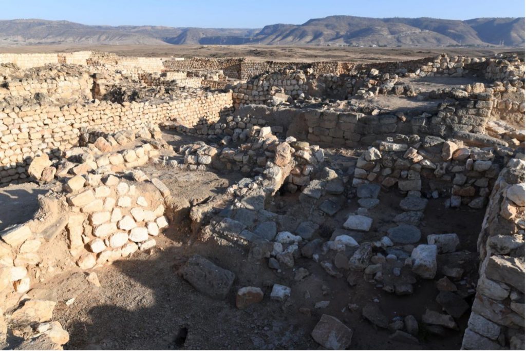
Figure 15. This view from Sumhurum’s ruins at Khor Rori faces inland toward the waterfall curtain of Wadi Darbat, visible across the arid Salalah plain in the center of the background hills.
- Khor Rori did not begin functioning as a trading port until late in the third century bc.
- Sumhurum city was also founded late in the third century bc.
- Seafaring activities at Khor Rori involved incoming/outgoing trade shipping. Minor repairs to ships and construction of small local fishing vessels are likely, though no large ships are known to have been built in the port.
- Importation of timber (e.g., teak) from India and Africa, as happened in northern Oman and the Gulf, is not recorded during any period at Khor Rori.
- No evidence is currently known that suggests timber species were once present in the Khor Rori/Wadi Darbat area that are not extant today.52
A very different situation exists at Khor Kharfot, where the largest remnant of the ancient forests that once existed in Arabia still grow close to the ocean. Further investigation is needed to determine if the timber species that we know exist here (and at Khor Rori) could have served [Page 247]Nephi in the building of his vessel. Certainly, the idea of timber being imported to Khor Kharfot from anywhere is so unlikely that it can safely be discounted. However, no pollen studies have yet been done at Khor Kharfot, or anywhere else along the Qamar coast, that might reveal additional species present in the past.
Both locations, therefore, have unresolved issues where shipbuilding timber is concerned and require further research.53
A Distinctive Mountain Nearby
The mountain where Nephi prayed “oft” and that both he and the Lord always referred to as “the” mountain is a significant feature of the Nephite Bountiful. It was a place of communion with Deity, made doubly sacred by the numerous revelations received there to guide Nephi in the building of the ship. Being a geological feature, we can expect that in 2,600 years it would have changed very little in appearance. Both sites have candidates for the mountain.
In Potter’s article, the real-world location of the proposed mount is not clearly stated. After many years of suggesting that Nephi’s mount was Jebel Samhan near Mirbat, east of Khor Rori,54 in Potter’s latest article this mount now appears under its lesser-known Arabic name, thus obscuring its location for the average reader.
There have always been insurmountable problems with this proposal. Jebel Samhan is indeed a high mountain, the highest in Dhofar, but being 31 km (19 miles) distant from Khor Rori (as the crow flies and therefore considerably more by ground), Nephi would then have to cover the same distance to return to camp, making a total of much more than 62 km (38 miles). This is too far to realistically suppose that he often traveled that far, walking or riding, to pray. Furthermore, I have verified several times that Jebel Samhan is not even visible from the highest points in the Khor Rori and Taqa area, thus jarring with the implication of the Lord and Nephi referring to it as “the” mount.
The inadequacy of Jebel Samhan as a candidate for Nephi’s mount may now be moot, as Potter in his article now proposes a much closer location that he names Jebel Taqa. Taqa or Taqah is the name of the district and of a town near Khor Rori, but it does not appear to be a recognized mountain. The proposed mount at Khor Rori is an elevated region visible on the west side of the travertine curtain that crosses Wadi Darbat and is surrounded by higher terrain inland and on each side, as can be seen in Figure 16.
[Page 248]
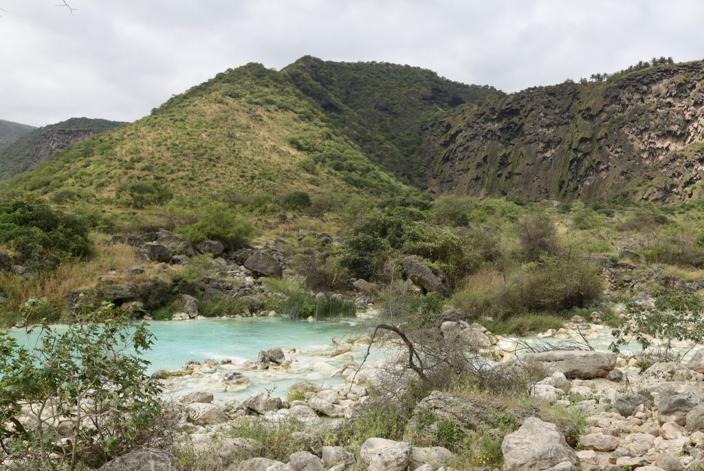
Figure 16. The “mount” inland of Khor Rori forms part of the travertine ledge across Wadi Darbat. In this view at its base, facing northwest, the mount, named Jebal Taqa in the Potter article, is the triangular hill occupying the left side of the image. Higher terrain stands on both sides of it.
At more than 5 km (3 miles) one-way inland from the coast at Khor Rori, this distance is a huge improvement over Jebel Samhan, and could now be feasibly reached on a regular basis. But I leave the reader to contrast this unremarkable hill with the obvious and impressive mountain on the west side of the bay at Khor Kharfot shown in Figure 17.
No Resident Population
Building on the earlier commentary regarding the multiple indicators in Nephi’s account that argue for the Old World “Bountiful” to have been an unpopulated place, the following images serve to visually contrast the two candidate sites. Figure 18 shows Khor Kharfot as it appears today; it is also how it would have appeared throughout history except for brief periods of occupation evidenced by its ruins. Figure 19, on the other hand, shows Khor Rori as it was from late in the third century bc onwards, dating that is now firmly established by its ruins. It remains possible that it may have functioned as a small harbor for local boats before that time, and there are ruins nearby that demonstrate habitation dating prior to Nephi’s day.
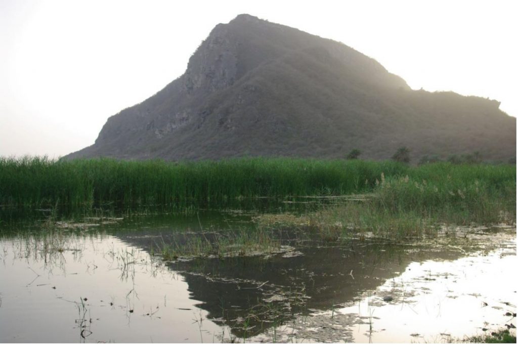
Figure 17. The “mount” at Khor Kharfot, facing westwards at sunset.
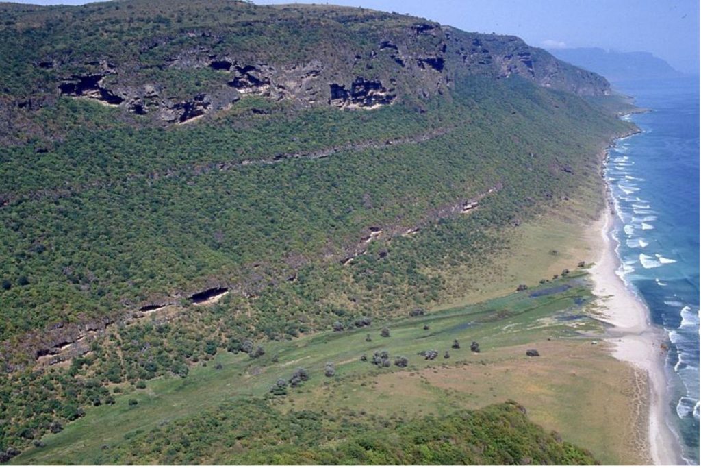
Figure 18. Facing east, this view graphically illustrates the unpopulated nature of Khor Kharfot, which has no resident population even today. The contours of the inlet originally offering access to the ocean, still visible today, closely follow the flat central part of the wadi.
[Page 250]
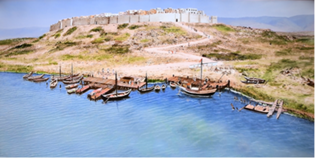
Figure 19. Representation of Khor Rori when it was active as a port, controlled by the fortified city of Sumhurum in the background. Image from a film produced by the government of Oman.
Nephi’s Ship
Nephi repeats that his ship was “not built after the manner of men” (1 Nephi 17:8, 9, 51; 18:1, 2), contra the assertion in Potter’s article that “it appears that Nephi’s ship, with the exception of an added deck, was rather conventional for the period.”55 Potter then displays a schematic that appears to be a modified version of what is indeed a completely conventional, very common dhow, a vessel long built on both sides of the Indian Ocean, as a “possible model for Nephi’s ship,”56 with suggested dimensions of about 80–120 feet (24–37 meters) in length, about 30 feet (9 meters) wide, and perhaps displacing over 100 tons.57 On the same page, a photograph of a model of just such a vessel is shown.58
A written evaluation of this proposed ship schematic (Figure 1 in Potter’s paper) was prepared for this author by an expert with theoretical and practical experience in ancient Arabian ship design. He noted that the design appears “more Indian or Pakistani” than an Arab dhow, and lists the following design defects that would probably render such a vessel inoperable in open water:
The way the waterlines are drawn indicate the ship was bow-down [adversely impacting steering and handling — author comment after clarification from the expert].
The waterlines as drawn are slightly curved, not straight.
[Page 251]The beam (maximum width) as stated as 30 feet [9 meters] is nowhere close to that on the plan [creating stability issues — author comment after clarification from the expert].
The draft at 8 feet [2.4 meters] seems not nearly enough for the ship to be stable and exposes too much topside [also creating stability issues — author comment after clarification from the expert].
The masts are vertical, rather than leaning forward slightly as on nearly all dhows.
The aft mast looks much too large in diameter.59
This response from an expert in Arabian ship design should encourage additional caution in all discussions about the style of Nephi’s ship. Aside from the logical requirement that the ship apparently had decking on which people could dance at the time of the great storm at sea, I find no echo of Potter’s assertions and claims about the design of Nephi’s ship in the scriptural text that was written, we must remember, by the man who built the ship.
I believe that the location of Bountiful, where Nephi’s ship was built, needs further resolution before we can comment more intelligently on the ship and draw even tentative conclusions about its style and size.
Hulled-Ship Options
While remaining open to other possibilities, my own assessment is that a hulled vessel with a deck remains the most likely style of vessel built. To imagine Nephi and his co-workers fashioning hundreds or thousands of nails to create a nailed vessel seems unlikely to me. That being the case, there are only a handful of other known ship-construction methods that can be considered for an ocean-going hulled vessel.
The clinker or lapstrake construction method dates back at least to the fourth century bc in Europe and is still used today. The edges of the wooden planks overlap each other before being joined together by nails, wooden “bolts,” or by gluing. A variation on this, also still used today, is carvel planking (not to be confused with caravel, a small ship design), where the planks of wood are laid out edge to edge and then fastened to a strong framework inside the hull. Both clinker and carvel approaches to hull design are illustrated in Figure 20.
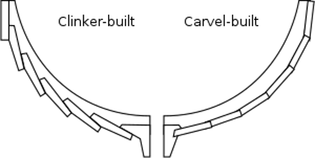
Figure 20. Comparing the clinker and carvel methods of wooden ship construction. Wikimedia, last edited December 24, 2022, https://commons.wikimedia.org/wiki/File:Clinker-carvel.svg. Licensed under the Creative Commons Attribution-Share Alike 4.0 International License.
Perhaps best known among students of Nephi’s ocean voyage is the time-honored sewn ship in which the timbers are sewn or lashed together with roping made of fibers, counterintuitively resulting in a [Page 252]vessel that can sail great distances with a sizeable load. I have already mentioned the sewn Sohar ship used in the successful “Sindbad Voyage” from Oman to China in 1980–1981, a highly publicized voyage that first drew enormous attention to this style of shipbuilding.60
Another large sewn ship built in Oman was the Jewel of Muscat that sailed from Muscat to Singapore in 2010.61 A scene during its construction is shown in Figure 21.
Of particular note is the Phoenicia, built to a 600 bc Phoenician design, that sailed many times further than the other ships named during several voyages from 2008 to 2019, and upon which the author experienced life as a member of the crew for two weeks in 2009. The Phoenicia, shown in Figure 22, was recently purchased by the Pennsylvania-based Heartland Research Group to be displayed in Montrose, Iowa (across the Mississippi River opposite Nauvoo), as a plausible example of a ship that could have carried Mulek to the Americas about the same time as the Lehite voyage.62
There is another very old ship construction method, mortise and tenon, in which the timber boards are skillfully fitted together and interlock (see Figure 23). Like sewn ships, this technique still allows the frame of the ship to flex in seas where a more rigid design may pull apart. Particularly fine workmanship can result in a vessel that is almost totally waterproof without additional measures. A later refinement known as the Phoenician joint was developed by the Phoenicians in the first [Page 253]millennium bc and spread rapidly. One marine-archaeologist suggested that this very development “could have given rise to the Phoenicians’ reputation for seafaring excellence.”63
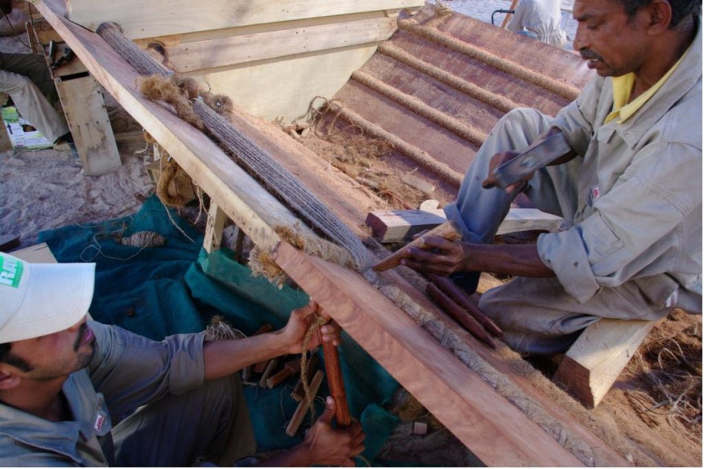
Figure 21. Caulking of the sewn ship Jewel of Muscat in Oman, photographed in 2009.
A generic factor in almost all hulled ships, however, is that they require caulking to plug up leaks that may threaten to sink the vessel. Caulking can be fashioned from a huge range of materials, many of them readily available in southern Oman. They included discarded roping, clay, moss, reeds, or other plant fibers soaked in tree resin or wax, and cloth soaked in animal fats and crushed limestone. Such materials could have been applied in a variety of ways, including being forced between planking by hammering, sewn into wadding placed along the seams, or coated on various components.64
[Page 254]
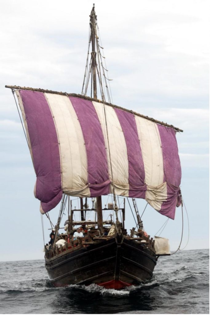
Figure 22. The Phoenicia 600 bc design sewn ship. Courtesy Leon Harmse, the Phoenicia Expedition.
Finally, ships have long been built combining more than one of these techniques. A well-known example is the Khufu “Solar Barque” ship dating from around 2600 bc now displayed on the Giza plateau in Egypt. It used mortise and tenon construction together with fiber lashings, a combination that aligns with my own tentative conclusions for Nephi’s ship. Despite being a non-specialist, my personal favorite is a mortise and tenon ship, with at least some timbers strengthened by lashings made of fiber ropes and/or strips of hide. Probably something, in fact, quite like the ship depicted in the Church’s recent series, Book of Mormon Videos, [Page 255]“The Lord Commands Nephi to Build a Ship: 1 Nephi 17-18.”65 A scene from this video is shown in Figure 24.
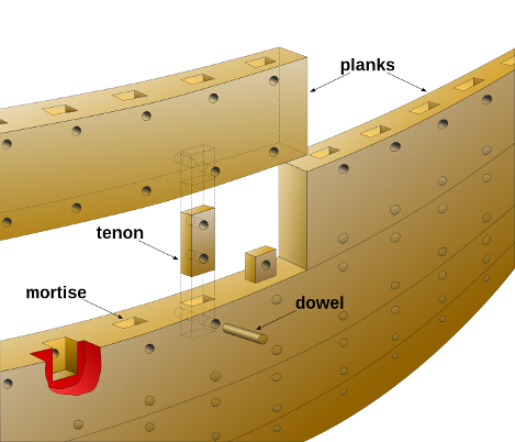
Figure 23. Drawing of a mortise and tenon joint hull by Eric Gaba, Jan. 2006, https://commons.wikimedia.org/wiki/File:Mortise_tenon_joint_hull_trireme-en.svg. Licensed under the Creative Commons Attribution-Share Alike 4.0 International License.
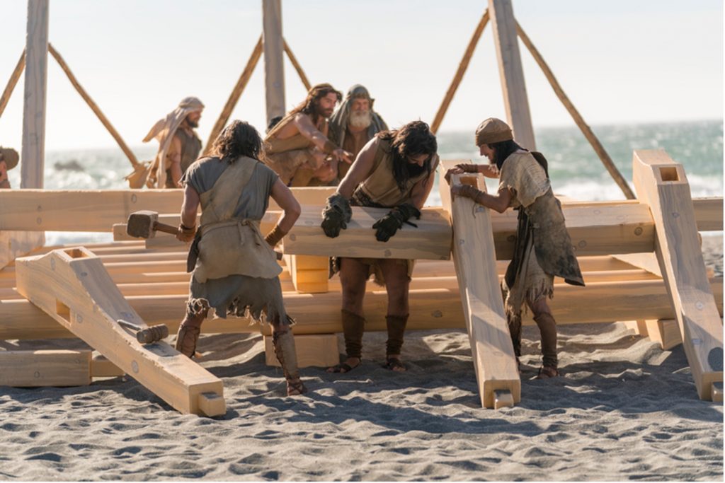
Figure 24. In the Church film of the Lehite exodus, admirably accurate in most regards, Nephi’s ship is built using the mortise and tenon method, with lashing suggested in various later glimpses while sailing. Image available at https://www.churchofjesuschrist.org/media/image/brother-ship-f608f8b.
Conclusion
In contrasting the two candidates for the Lehite Bountiful in light of scriptural evidence, Khor Rori appears to lack several foundational elements required by Nephi’s text. Almost certainly it lacks the wild fruit that greeted the Lehite group upon arrival, and certainly it has no distinct nearby mountain where Nephi often prayed. And, contrary to the multiple textual indicators, Khor Rori was certainly inhabited in Nephi’s day.
Khor Rori lacks the all-important timber suitable for constructing a ship, thus requiring timber to be shipped from India. However, the archaeological evidence provides no indication that Khor Rori ca. 600 bc was functioning as a port for large ships and thus likely could not have [Page 256]provided Nephi with either imported timber or shipbuilding expertise. This article notes, however, that the issue of shipbuilding timber still requires further research to reach resolution for both candidate locations.
From a scriptural perspective, Khor Kharfot matches the descriptors in Nephi’s account more closely than does Khor Rori and, in fact, is the only location where all of the requirements are met. The pristine and isolated Khor Kharfot also seems to be reflected in the implications of Nephi’s text much more closely than does Khor Rori in a populated Salalah bay. Those who believe in the historicity of Nephi’s account can point to the remarkable fact that not one, but two locations — separated by just 120 km (75 miles) by air — are a remarkable contrast to over 1,600 km (1,000 miles) of the eastern Arabian coast. If it should eventually transpire that Khor Rori is indeed where Nephi built his ship, I would be surprised, certainly, but would still heartily embrace additional support for the Book of Mormon as an authentic account of an Arabian journey 2,600 years ago.
As the Book of Mormon continues its march out of obscurity, the unfolding of its Old World setting to date should engender confidence [Page 257]that further clarity regarding Bountiful, Nephi’s ship, and its great ocean voyage to the New World remain ahead of us.
[Author’s Note: I appreciate the talents of Jennifer Powell evident in the superb work she did creating the maps used in this paper.]
For the use of tamarind in ship construction specifically, see Sila Tripati, “Traditional Boat-Building and Navigational Techniques of Southern Orissa,” Journal of the Royal Asiatic Society of Sri Lanka, New Series 42 (1997): 15–27, https://www.jstor.org/stable/23731497. Page 18 lists tamarind as among the woods that were used for boat planking in Sri Lanka.
Go here to see the 12 thoughts on ““Nephi’s “Bountiful”: Contrasting Both Candidates”” or to comment on it.