


[Page 257]Abstract: The purpose of this article is to provide several examples of how meaning, understanding, and interpretation of scriptures may be enhanced when scriptures are read in their geographical context. Many scholarly articles seek exclusively to break new ground in meaning and meaning-making, to essentially produce new knowledge. This article hopes to break new ground both in terms of new knowledge (insights) as well as in the pragmatics of giving readers additional tools and opportunities for exploring the scriptures in fresh ways. In particular, this article will also highlight several free geographical tools that can improve one’s learning with the scriptures, with particular focus on Google Earth and the BYU scriptures.byu.edu/mapscrip tool (hereafter referred to as Google Earth Bible or GEB). The hope is that this article will, through the tools discussed, create opportunities for others to create new knowledge for themselves through scripture study.
Why Geographical Visual Learning?1
Humans are visual learners. The content area of scripture is primarily conceptual and abstract, and thus many readers struggle to master the core fundamentals of history, geography, and themes of the scriptural texts. Without such fundamentals, learners are adrift in an ocean of content without a meaningful map to order and make sense of it all. Visually immersive learning environments can significantly enhance learning gains. Such learning gains are possible when abstract concepts are visually concretized.
Scripture Tools: Introduction to Google Earth and Google Earth Bible (GEB)
In this article I will review several geographical tools that help to contextualize stories, which can aid in understanding the scriptures and drawing out meaning from them. Then using these tools I’ll demonstrate how the meaning of a variety of scriptural passages may be enhanced by reading the scriptures in geographical context. I will conclude by providing other suggested geographical and visual learning with scripture resources.
What is Google Earth?
Google Earth2 is a one of the most popular geobrowsers.3 “A geobrowser, or a virtual globe, is a three-dimensional, computer-generated representation of the Earth or another world. Using computer modeling, satellite and aircraft imaging, it allows the user to view different aspects of the environment by rotating it and changing the angle, as if flying over an area by airplane. A geobrowser may include things like roads and buildings. It can also show weather patterns, like the movement of storms, as well as updated images of the changing geographic landscape including disasters.”4
Why is Google Earth Useful?5
Three features make Google Earth useful to users generally. These reasons also matter to students of scripture. First, the interface is user-friendly. Almost no experience is required to navigate around Google Earth in order to explore any corner of the world. Without much effort, a student of the Bible can virtually visit the Holy Land. Second, Google Earth provides the spatial visualization of abstract concepts. Maps are abstract representations of reality that only focus on certain details. For example, road maps will depict roads and their maze of interconnections. However, such a map is unlikely to give much information about surrounding vegetation, terrain elevation, the size of buildings (if there are any), etc. For many Bible readers, static, flat, two-dimensional maps are the primary geographical visualizations available to them. Google Earth brings the reality of Holy Land geography to life. Third, Google Earth allows for outside data to be imported into the system. For example, the Panoramio feature displays geographically relevant pictures uploaded by the community of users.6 If someone wanted to visit the Dome of the Rock in Jerusalem via Google Earth, not only would they be able to see a bird’s-eye aerial view, but with Panoramio they could also see dozens of pictures of that location provided by other Google Earth users. A related Google Earth feature is called 360 Cities, which provides 360-degree views of various locations. It is now possible to take immersive virtual tours of Jerusalem and many other locations throughout the world essentially for free.
Scriptures.byu.edu/mapscrip or Google Earth Bible (GEB)
The scriptures.byu.edu/mapscrip, or Google Earth Bible (GEB), tool is an experimental project of scriptures.byu.edu. Google Earth Bible is designed so that when a user opens a chapter of the Bible in this tool, a Google Earth plug-in opens to visually mark and identify each of the locations mentioned in that chapter. This tool can provide many benefits to learning with scripture, helping readers to visualize and concretize the locations mentioned. Readers can see the locations of cities of Canaan conquered by the invading Israelites. Readers can trace the locations of cities or nations cursed or blessed by the words of Isaiah. And readers can follow along geographically as the apostles sally forth in Acts to spread the gospel message throughout the Roman Empire.
Examples of Learning with Scripture by Reading Geographically
This article will highlight a few scripture passages whose meaning can be enhanced with Google Earth visualizations. Though still images are provided in this article, it is recommended that readers of this article open each individual chapter map highlighted by using the links to the GEB and other Google Earth related tools. The links are next to section headers in this article. Readers will then see for themselves the full effect and utility of these tools for enhancing learning with scripture. (For best results with the GEB tool, use a Firefox browser and download the Google Earth plug-in. As of early 2014, the GEB tool is not available on smart devices.)

Noah and the Flood (Genesis 8) http://scriptures.byu.edu/mapscrip/#gen/8 (click the image to enlarge)
Noah and the flood story is one of the most famous stories from the Bible. Genesis records that after Noah built the ark and rode out the storm, the waters abated. The Bible states that Noah’s ark came to rest “upon the mountains of Ararat” (Genesis 8:4). No one has final confirming evidence of where the mountains of Ararat are located. But long-standing European tradition identifies the location as a dormant volcano in far eastern Turkey near the border with Armenia.7 With the GEB tool, a user can see this spectacular snow-capped mountain. Even though there is no certainty that Noah landed his ark there, the geographical visualization helps to illustrate the story.
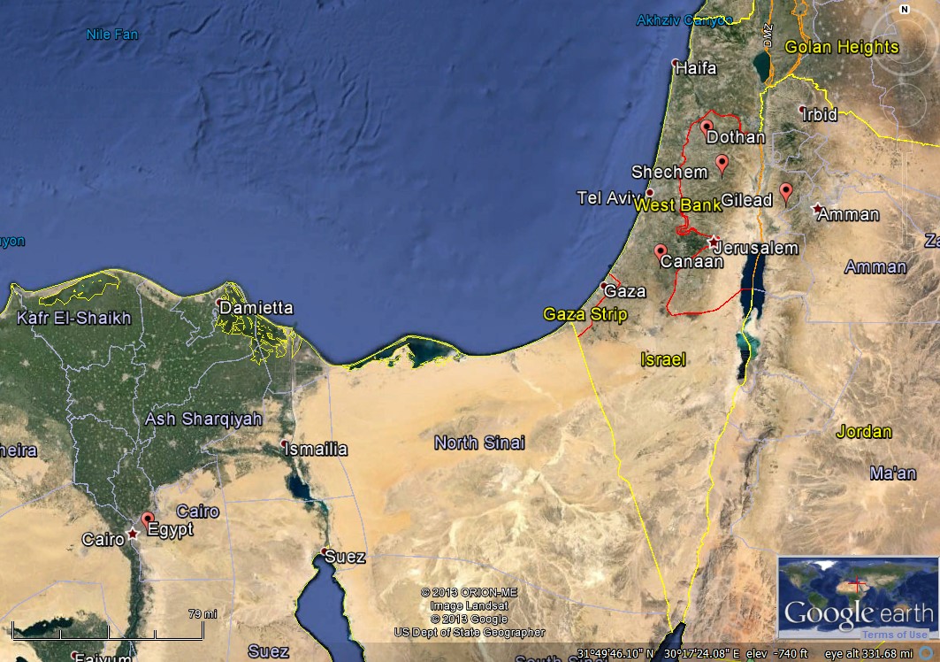
Joseph is Betrayed by His Brothers (Genesis 37) http://scriptures.byu.edu/mapscrip/#gen/37 (click the image to enlarge)
In Genesis 37, Joseph received the coat of many colors from his fathers and recounted his dreams of leadership, thereby inviting the jealousy of his brothers. The chapter continues with Joseph sent by Jacob to check on the status of his brothers feeding the flocks in Shechem. Not finding them in Shechem and learning that his brothers went to Dothan, Joseph pursued his journey there. His brothers conspired against him, sold him to Ishmeelites from Gilead, who in turn took him down to Egypt. For most readers of this story, the geographical locations of this story are not easily accessible. But with the GEB tool, most of the key locations mentioned in Genesis 37 are highlighted.8 A reader can see the long distances that Joseph travelled to find his brothers leaving Hebron, heading to Shechem some 50 miles north, and then further northwest to Dothan, at least another 16 miles. And all of these distances are calculated as-the-crow-files, not taking into account the tremendous geological contours (so easily visible on Google Earth) that shape the area which would add significant time and length to the journey. Joseph’s journey to find his brothers could have easily taken a week. A reader can also capture a small glimpse of the economic interconnectedness of the ancient world, that despite long distances caravanners from Gilead would cross through Canaan to trade in Egypt.
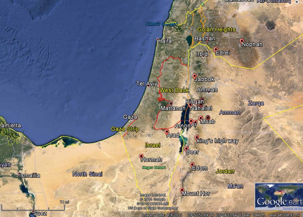
Israelite Journeying in Jordan (Numbers 21) http://scriptures.byu.edu/mapscrip/#num/21 (click the image to enlarge)
Numbers 21 narrates the journeys of the Children of Israel in the land east of the river Jordan. The numerous geographical references in these passages are usually skipped over because, without an easy way to place such references contextually, they are likely a distraction to the rest of the narrative. Using the experimental GEB tool, the locations are visually accessible, geographically contextualized, and more meaningful to the reader. Readers can more easily trace the narrated journey of the Israelites through the lands of Jordan, mark the locations mentioned in the Israelite songs, and identify the cities captured by the Israelites after they defeated King Sihon in battle.
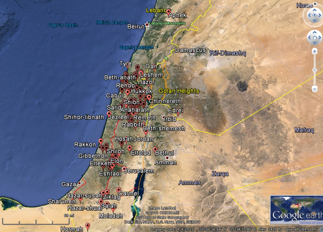
Israelites Inherit the Land (Joshua 19) http://scriptures.byu.edu/mapscrip/#josh/19 (click the image to enlarge)
One of the purposes of the Book of Joshua is to identify the cities and lands inherited by the Israelites. Most of these geographical locations and cities are foreign to modern readers. Like other Biblical passages with numerous geographical references, these chapters are skipped over, or little understood if read. However, these locations definitely meant something to the ancient Israelites who read these passages, lived in these locations, or were familiar with them. Now using GEB, modern readers can more easily see the geographical context of such locations.
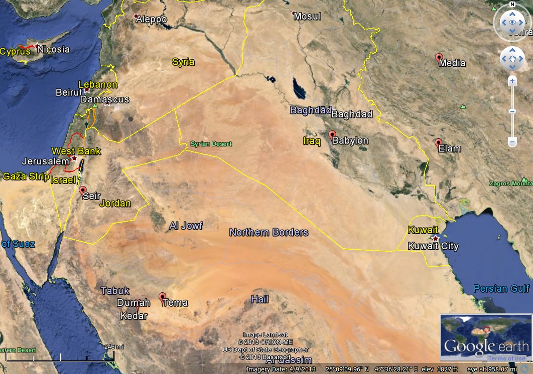
Poetry and Prophecy (Isaiah 21) http://scriptures.byu.edu/mapscrip/#isa/21 (click the image to enlarge)
Isaiah, the writer of beautiful prophecies and poetry, often used the names of geographical locations to heighten the meaning of his poetry or to identify a particular region, city, or town that was marked for curses from God. The ancient, once-glorious Babylon is such a city, and one of the most “well-known” cities in the Bible.9 Babylon figures prominently in the religious and theological imagination of Jews and Christians. But in reality it is an enigma for most in the Judeo-Christian tradition.10 Few Bible readers have visited the location, in modern day Iraq, about 53 miles due south of Baghdad on a branch of the Euphrates river.
Biblical readers’ ideas of the city of Babylon are quite imaginative. Yet the existing reality of the city, anciently and now, is far more constrained. GEB allows readers to see that its few remaining features are pitifully scant, to the point that one could apply to the archaeological remains of Babylon the remarks made by Isaiah about the fall of the ancient Babylonian king:
“Thou shalt take up this proverb against the king of Babylon, and say, How hath the oppressor ceased! the golden city ceased!…Art thou also become weak as we? art thou become like unto us? Thy pomp is brought down to the grave, and the noise of thy viols: the worm is spread under thee, and the worms cover thee. How art thou fallen from heaven, O Lucifer, son of the morning! how art thou cut down to the ground, which didst weaken the nations!” (Isaiah 14:4, 10-12)
Similarly, reading Isaiah 21:9 with GEB, the reality of Isaiah’s words are visually reinforced “Babylon is fallen, is fallen; and all the graven images of her gods he hath broken unto the ground.”

Babylon (click the image to enlarge)
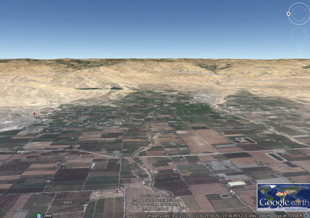
Abundance in the Mountains and Valleys (Joel 3) http://scriptures.byu.edu/mapscrip/#joel/3 (click the image to enlarge)
Joel, one of the Old Testament minor prophets, ends his writing with a prophecy of future times of restoration and abundance for Judah, Jerusalem, and the surrounding region.
“And it shall come to pass in that day, that the mountains shall drop down new wine, and the hills shall flow with milk, and all the rivers of Judah shall flow with waters, and a fountain shall come forth of the house of the LORD, and shall water the valley of Shittim.” (Joel 3:18)
The GEB tool helps readers see that the valley of Shittim is one of the lowest spots on earth. The view here is facing eastward from Jericho, which is on the opposite side of the valley. The valley of Shittim is watered primarily by flows from various wadis that tumble down the east bank of the Jordan valley mountains.11 Flying in to the “valley of Shittim” on the GEB tool, the hills and mountains that mark the valley frame the view. From this vantage point one can turn in all directions and see that these barren hills and mountains are the location of Joel’s future fulfillment. However, Joel’s prophecy informs us that one day a fountain emanating from the House of the Lord in Jerusalem some twenty-five miles away will water the vast, productive plains of the southern Jordan valley. These hills and mountains—whose desolation, aridity, and sterility the GEB tool has illustrated for us—will one day spring forth with the waters, milk, and wine of abundance and prosperity.
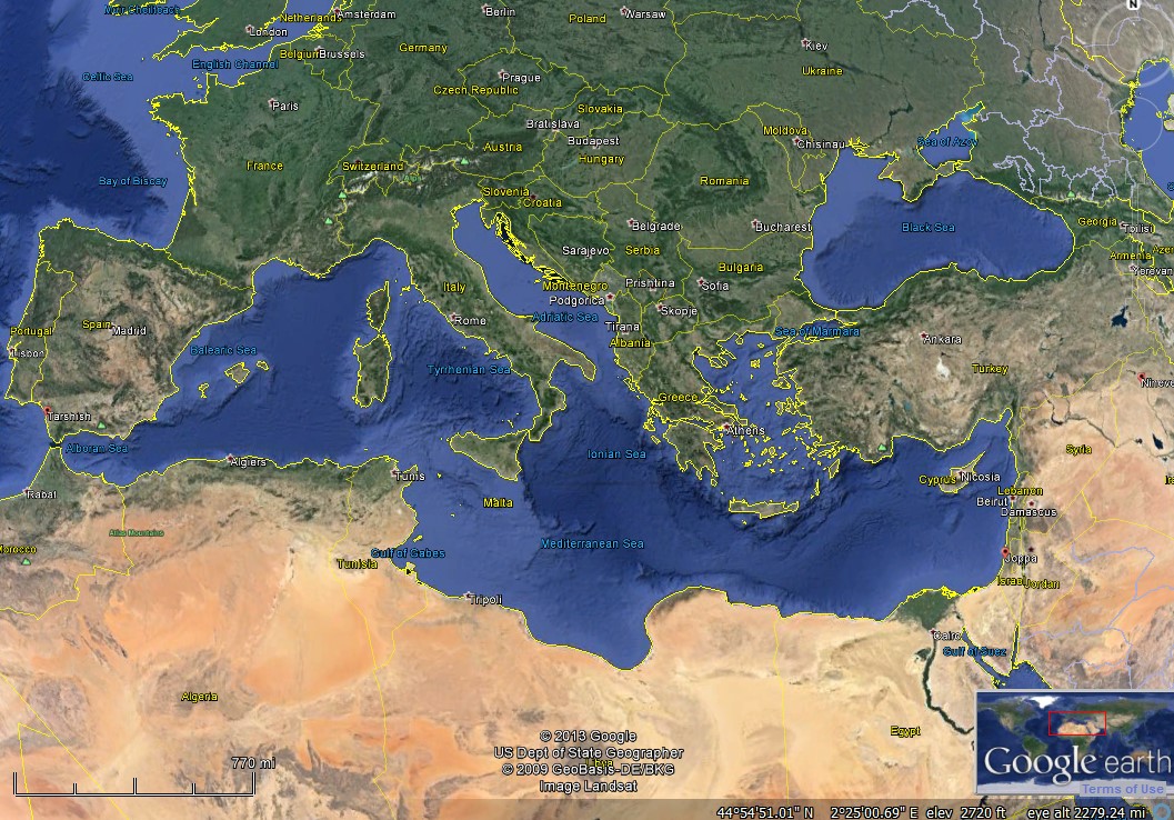
How Far Can One Run from the Lord (Jonah 1) http://scriptures.byu.edu/mapscrip/#jonah/1 (click the image to enlarge)
The story of Jonah’s deep reluctance to respond to God’s call to prophesy against the city of Nineveh is well known. We all can recount that Jonah attempted to flee to Tarshish. Though the exact location of Tarshish is unknown, we do know that it was far away. The current iteration of the GEB tool places Tarshish on the Atlantic seaboard of Spain, where, according to some traditions, Tarshish was located. Other traditions suggest Tarshish was somewhere in Africa or the Mediterranean island of Sardinia, where there was an ancient Phoenician trading colony.12 When Jonah 1 is viewed in GEB it is visually unmistakable that Jonah was doing everything possible to flee to the ends of the earth—anywhere but in the direction of Nineveh. This is a visually powerful teaching tool. Using the GEB tool, readers understand that not only was Jonah trying to get away, he was trying to get as far away in the opposite direction from Nineveh as was humanly possible. If Jonah had had the ability to flee to the New World, he just might have. If Jonah had received his mission call in the 1960s and had any way to board a lunar rocket, he would have done so.
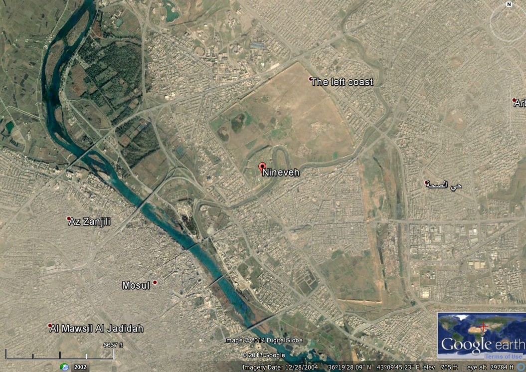
The Ancient Assyrian Capital City of Nineveh (Jonah 3) http://scriptures.byu.edu/mapscrip/#jonah/3 (click the image to enlarge)
Like the city of Babylon, ancient Nineveh was a major capital city.13 It also commands quite an imagination among Biblical readers, influenced in part by the narrated description of the city in Jonah. “Nineveh was an exceeding great city of three days’ journey [across]” (Jonah 3:3) and “Jonah began to enter into the city a day’s journey” before he began his message (Jonah 3:4). Without any real visuals or experience to guide readers, one might conclude that Nineveh was many dozens of miles wide, perhaps rivalling the physical size of major cities today. The reality, like we saw with the city of Babylon, is far more circumspect from today’s city-size standards, even though Nineveh was a great and a mighty city in its time.14 By clicking on the “Nineveh” link in Jonah 3 in the GEB tool, an aerial perspective of the ill-formed parallelogram shape formed by the ancient walls of Nineveh come into view, now surrounded by the modern-day city of Mosul, Iraq. From this view we see that ancient Nineveh was more like 3 miles north-south and about a 1.5 miles across at its widest spot where the Khosr river bisects the ancient city as it flows west into the south-flowing Tigris. This is still a very large city, perhaps one of the largest cities in the world in its heyday (see image below). But the city was nowhere near the size the Jonah narrator imagined. Urban development from the modern Iraqi city of Mosul has since overtaken most of the southern half of the ancient city of Nineveh. The northern half is mostly empty with some agricultural land abutting the massive mound where the mighty palace of Sennarcherib once stood near the temples dedicated to a host of Assyrian gods and goddesses.15 Seeing the remains of ancient Nineveh brings a reality to the story of Jonah that is not possible through words alone.16
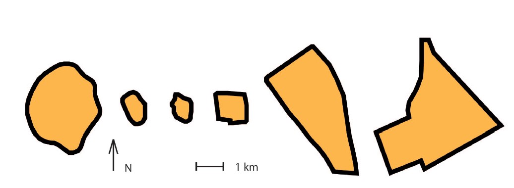
“Form and relative size of some of the largest Ancient Near Eastern cities. From left to right arranged chronologically according to period with largest extent of the cities from c. 2700-600 BC: Uruk (550 ha), Ur (70 ha), Ebla (50 ha), Qatna (100 ha), Nineveh (700 ha), Babylon (800 ha). Picture by O. Pedersén”17 Jerusalem was only about 50 ha large in 600 BC, about the size of Ebla in the image above, and about the size and population of the Brigham Young University campus. For comparison, Nineveh was about 14 times larger than 600 BC Jerusalem and Babylon was about 16 times as large. (click the image to enlarge)
Up to Jerusalem, Down to Jericho: Movement in the Gospels
In the Bible movement towards Jerusalem is described in upward terms (e.g., 2 Kings 12:17; Ezra 4:23; Luke 2:42; Galatians 2:1), away from Jerusalem in downward terms (e.g., Mark 3:22; Acts 8:28). Sometimes modern readers conceive of geographical “up” as north and “down” as south. In ancient Israel, the words “up” and “down” in geographical contexts usually indicated elevation. Jerusalem is located on one of the highest elevations in Judah. Therefore, travel toward Jerusalem typically involved ascending to a higher elevation. Using the Google Earth elevation feature (on the bottom right of the Google earth screen to the left of the “eye alt”18 reading), these aspects of the geography are easily accessible. From Nazareth (the boyhood home of Jesus) to Jerusalem would be a rise of more than 1000 feet. Thus we read: “And when he was twelve years old, they went up to Jerusalem after the custom of the feast” (Luke 2:42, emphasis added). Travel from Capernaum (a base of ministry for Jesus, situated on the northern shores of the Galilee) to Jerusalem is a rise of more than 3100 feet: “Behold, we go up to Jerusalem; and the Son of man shall be betrayed unto the chief priests and unto the scribes, and they shall condemn him to death” (Matthew 20:18, emphasis added). To this literal understanding of ascending to Jerusalem, Jewish and Christian thinkers have added a metaphorical understanding as well, as if a spiritual ascension occurs when one goes up to Jerusalem.
Contrasted to Jerusalem is Jericho, the city at the lowest elevation in the world. Travel from Jerusalem to Jericho involves an elevation drop of more than 3100 feet. “And Jesus answering said, A certain man went down from Jerusalem to Jericho, and fell among thieves, which stripped him of his raiment, and wounded him, and departed, leaving him half dead” (Luke 10:30, emphasis added). This lowest-of-the-earth elevation of the area near Jericho is particularly important because Jesus was baptized in the Jordan River, not far from Jericho and near to where the river flows into the Dead Sea. When the scriptures record that Jesus descended below all things (D&C 88:6; 122:7-8), this is both literally and figuratively true. Again, language in the scriptures can be visualized and more understandable using geographical technology.
Caesarea Philippi: Rock Imagery and Jesus as the True Son of the Living God (Matthew 16) http://scriptures.byu.edu/mapscrip/#matt/16 (click the image to enlarge)
One significant example of how using geographical and visual tools can improve learning with scripture is the story of Jesus teaching his disciples at Caesarea Philippi.
“When Jesus came into the coasts of Caesarea Philippi, he asked his disciples, saying, Whom do men say that I the Son of man am? And they said, Some say that thou art John the Baptist: some, Elias; and others, Jeremias, or one of the prophets. He saith unto them, But whom say ye that I am? And Simon Peter answered and said, Thou art the Christ, the Son of the living God. And Jesus answered and said unto him, Blessed art thou, Simon Barjona: for flesh and blood hath not revealed it unto thee, but my Father which is in heaven. And I say also unto thee, That thou art Peter, and upon this rock I will build my church; and the gates of hell shall not prevail against it. And I will give unto thee the keys of the kingdom of heaven: and whatsoever thou shalt bind on earth shall be bound in heaven: and whatsoever thou shalt loose on earth shall be loosed in heaven. Then charged he his disciples that they should tell no man that he was Jesus the Christ.” (Matthew 16:13-20)
Context is deeply significant for understanding and meaning. Many Bible readers recognize this passage and understand its relevance to understanding the doctrines of priesthood and revelation as well as for declarations about the true identity of Jesus. Yet few readers pause to ask, “Why did Jesus choose this location for this teaching moment?” Using GEB we notice several things. First, in the previous chapter (Matthew 15), Jesus and his disciples had been in the Galilee area teaching near Magdala and Bethsaida. Both of these towns were on the northern shore of the Galilee. Then in Matthew 16, Jesus and his disciples head to Caesarea Philippi. Plotting the distance from the northern shores of the Galilee to this location on modern day roads reveals a 60 km route (= 37.5 miles). Travelling as-the-crow flies is about 25 miles. Either way, this is a long distance to travel on foot, likely a day’s journey or more. So now the question, why did Jesus have his disciples join him on a 25+ mile hike only to ask “Whom do men say that I am?” Could not have Jesus asked the same question back in Capernaum or any other location where they had been? How does the geographical context inform the teaching moment for why Jesus purposely had his disciples walk such a long distance to answer a seemingly simple question?
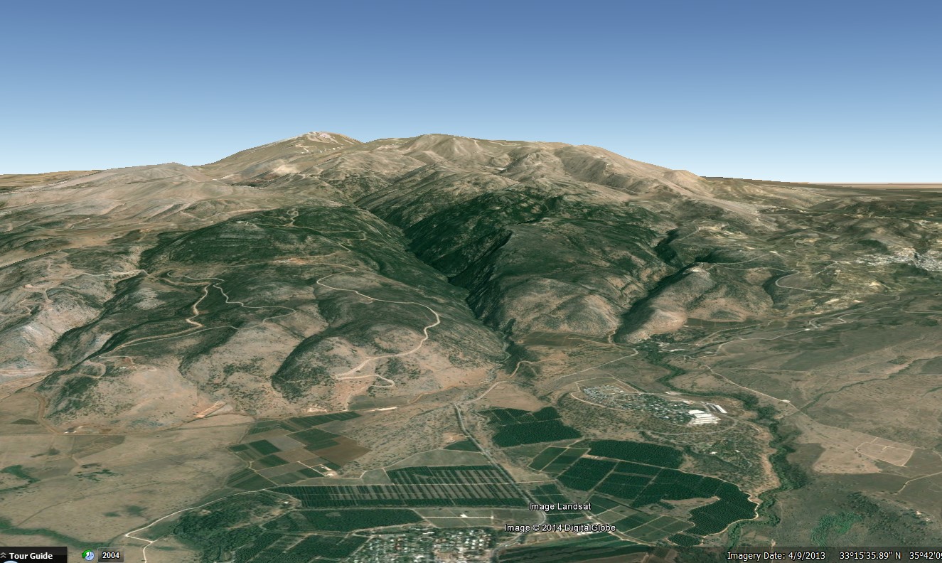
Caesarea Philippi sits at the base of the most massive mountain in the region of Israel, Mount Hermon.19 If one were only reading the words of Matthew 16 and had no access to visual and geographical contextual clues, it would be impossible to appreciate, let alone be aware of, the meaning-making significance of the geography for why Jesus chose this location for this teaching moment. It is standard procedure for Biblical interpreters to focus on the word play in Jesus’ statement to Peter, because words are all they can see if they are not reading Matthew 16 on site. “That thou art Peter, and upon this rock I will build my church” (Matthew 16:18). The Greek name Peter is related to the Greek word for rock. So Peter is the great rock upon which his church will be built. Literary interpreters can see those words and thus see the significance of that statement. What interpreters miss, if they do not see the visual and geographical context of the dialogue setting, is the use of real rocks for Jesus to make his point. At 9232 feet in elevation, Mount Hermon is the largest and most immovable rock anywhere for hundreds of miles in any direction.20 When Jesus said to Peter “upon this rock I will build my church; and the gates of hell shall not prevail against it” (Matthew 16:18), Jesus could not have found a better teaching backdrop to reinforce the reality that the gates of hell will not prevail against Christ’s work, just as it is incomprehensible to imagine Mount Hermon being moved. That is why Jesus had his disciples hike for some 25+ miles to have a teaching moment that on paper could have occurred anywhere. Teaching that message from the foot of Mount Hermon was a necessary ingredient for the full-force of Jesus’ teachings to sink in.
There was another significant, geographically significant reason that Jesus had this interchange with his disciples at Caesarea Philippi. But this reason is no longer visible on Google Earth. Archaeologists have found evidence of a temple dedicated to Caesar Augustus in or near Caesarea Philippi.21 If Jesus was at, or near the temple dedicated to Augustus when he asked his disciples, “Whom do men say that I am”, the meaning and significance of Peter’s reply “Thou art the Christ, the Son of the living God” (Matthew 16:16) would be deeply enhanced. Augustus, the Roman Emperor, was the adopted son of Julius Caesar. After Julius Caesar died, the Roman senate voted him divine honors, in effect, giving him the title of a god.22 What did that make Augustus? The adopted son of a god. More precisely, the adopted son of a dead god.
In contrast, Peter says, “Thou art the Christ, the Son of the living God” (Matthew 16:16, emphasis added). Jesus is not an adopted son of a god. And he is definitely not a son of a dead god. Jesus is the true son of the living God. The full meaning of Peter’s grand declaration would hardly be lost on anyone with eyes to see and ears to hear at Caesarea Philippi.
Furthermore, there was a natural spring that issues forth from the base of Mount Hermon at this location. It was believed that a chthonic god controlled the springs and access to the underworld, or Hades. Worshippers would seek knowledge from the god by asking a question (typically a yes or no question),23 making an animal sacrifice, and then throwing that sacrifice into the cavernous spring of water. If the animal sacrifice sunk and did not return, the god had accepted the sacrifice and provided an affirmative response. If the bloody animal sacrifice remerged then this signaled a negative godly response and a rejection of the sacrifice. These ideas may better contextualize the statements by Jesus to Peter “Blessed art thou, Simon Barjona: for flesh and blood hath not revealed it unto thee, but my Father which is in heaven. And I say also unto thee, That thou art Peter, and upon this rock I will build my church; and the gates of Hell shall not prevail against [the Church]” (Matthew 16:16, emphasis added).
Other Useful Geographical and Visual Resources for Learning with Scripture24
The Open Bible Project
The Open Bible project25 has attempted to correlate geographically named locations in the Bible with Google Earth. Though some of the work is inaccurate, it is still a helpful resource to visually and geographically contextualize Biblical stories and passages. There are a variety of useful features on this website. First, there are free, downloadable Google Earth map files for most of the named locations in the Bible. These files can be downloaded by individual biblical book or all at once. The website has an atlas section that “lists all the [Bible] places alphabetically, complete with thumbnails, verses, and photos.”26 Map overlays are also available for users to download. This feature is helpful for those wishing to see how maps correlate with satellite imagery of the Holy Land. As of early 2014, more than 18,350 photos of 1168 Biblical places are available on the website.27 Finally, the website provides a free, downloadable Google Earth map file outlining many of the bodies of water mentioned in the Bible.
The Digital Archaeological Atlas of the Holy Land
The Digital Archaeological Atlas of the Holy Land “is an international project that brings together experts in information technology including Geographic Information Systems (GIS) and the archaeology of the Holy Land (modern Israel, Palestine, Jordan, southern Lebanon, Syria and the Sinai Peninsula) to create the first on-line digital atlas of the region held sacred to the three great monotheistic faiths – Judaism, Christianity and Islam…This website and its content will serve as the prototype “knowledge node” of a more comprehensive Digital Archaeological Atlas Network for the Mediterranean region.”28
The Digital Archaeological Atlas of the Holy Land (click the image to enlarge)
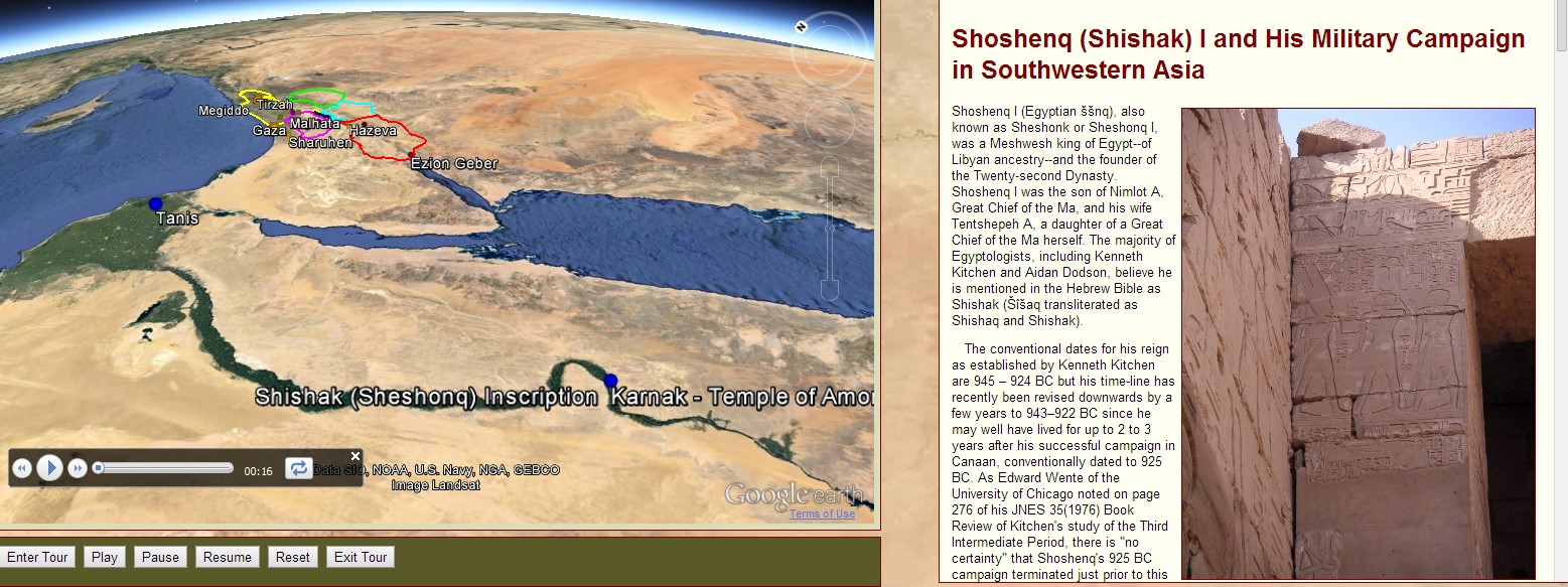
Relevant to Old Testament study is a Google Earth tour, available at the Digital Archaeological Atlas of the Holy Land, of Egyptian Pharaoh Sheshonk’s military campaign into Israel ca. 925 BC.29 Sheshonk is known as Shishak in the Old Testament. 1 Kings 11:40, 1 Kings 14:25, and 2 Chronicles 12:2-9 tell the story. Rehoboam, son of Solomon, was king in the southern Kingdom of Judah. The Bible asserts that God allowed Shishak to dominate Judah because of faithlessness in Judah, “Thus saith the Lord, Ye have forsaken me, and therefore have I also left you in the hand of Shishak” (2 Chronicles 12:5). Rehoboam and the princes of Judah then humbled themselves, acknowledging the righteousness of the Lord. God allowed Shishak to plunder the treasures of both temple and palace as a punishment to Judah, before the Pharaoh returned to Egypt. This Biblical episode has now been mapped to Google Earth.
Google Earth 3D Buildings (click the image to enlarge)
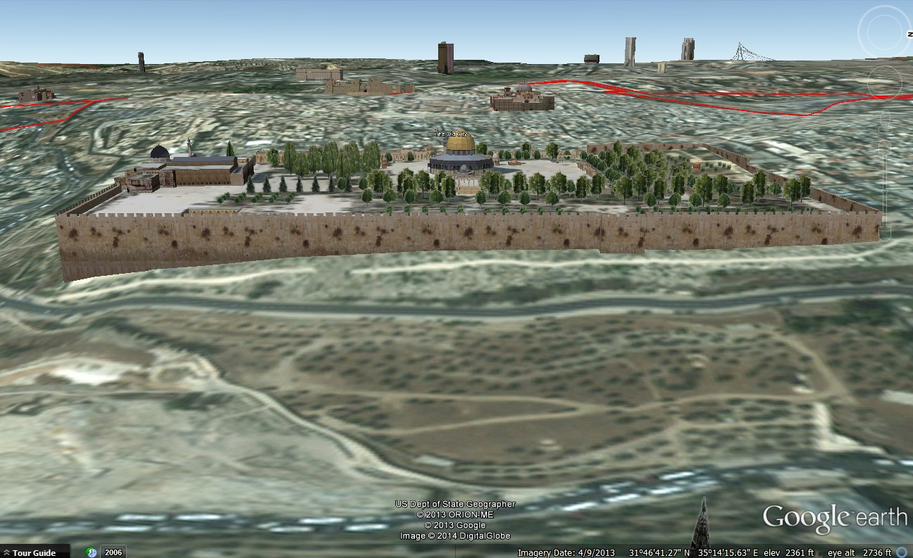
Many cities and locations in Google Earth have 3D visualizations of buildings.30 To view these structures, users must check the “3D Buildings” checkbox in the Google Earth side bar. If one visits Jerusalem via Google Earth, the following buildings are visible: The Temple Mount, including the walls surrounding the Temple Mount, the Dome of the Rock, and the Al-Aqsa Mosque; the Tower of David Citadel; and the Church of the Holy Sepulcher.
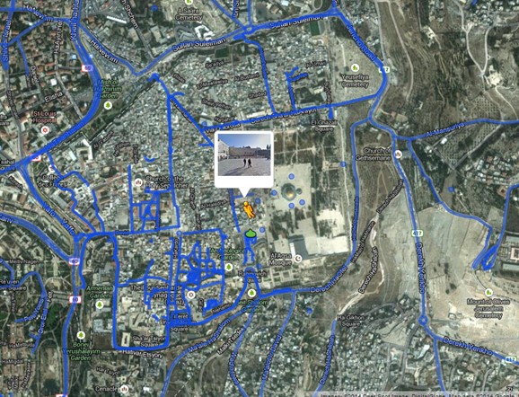
Virtual Walking Tour of Old City Jerusalem in Google Maps http://goo.gl/maps/h1Njj (click the image to enlarge)
Many people want to walk where Jesus walked. Going to Jerusalem can help. But even then, most of Jerusalem from the time of Jesus has been paved over or built over by later generations. Nevertheless, walking the streets of Old City Jerusalem gives one a sense of place. Now it is possible to replicate that experience with a walk through the Old City via Google Maps. To take the tour of Jerusalem, click the link above and then click and hold on the orange figure ![]() . Then when the blue lines appear on the map, move the orange figure to anywhere on the blue lines in the Old City and let go. You will be inserted into the Old City of Jerusalem.
. Then when the blue lines appear on the map, move the orange figure to anywhere on the blue lines in the Old City and let go. You will be inserted into the Old City of Jerusalem.

Virtual Walking Tour of Ancient Archaeological Site Tel-Hazor in Google Maps http://goo.gl/maps/BJ3vg (click the image to enlarge)
Hazor was an ancient city, important for hundreds of years in the Galilee region and frequently mentioned in the Bible: Joshua 11:1,10-11,13; 12:19; 15:23,25; 19:36; Judges 4:2,17; 1 Samuel 12:9; 1 Kings 9:15; 2 Kings 15:29; Nehemiah 11:33; and Jeremiah 49:28,30,33. During the 9th century BC, Hazor was the largest fortified city in Israel. To take the tour of Hazor, click the link above and then click and hold on the orange figure ![]() . Then when the blue lines appear on the map, move the orange figure to anywhere on the blue lines and let go. You will be inserted into a virtual tour of the archaeological site.
. Then when the blue lines appear on the map, move the orange figure to anywhere on the blue lines and let go. You will be inserted into a virtual tour of the archaeological site.
Conclusion
Learning with scriptures is an ongoing quest. Many tools and approaches have long been available to enhance our understanding: historical, literary, philological, theological, word searches, textual analysis, and so forth. With the advent and development of new technologies, especially visual and geographical tools, learners are now able to explore the scriptures in new ways, to visit the scriptures geographically, to read on location, to experience the reality that the Bible occurred in a real place, defined and influenced by geography, by time and place. The tools reviewed here provide a platform for developing new insights and knowledge about the scriptures. Indeed, these tools enhance our learning with scripture.
1. Though there is general agreement that visualizations are valuable for learning, there still is considerable debate about how humans best learn through visuals, how to design visual-based learning, and so forth. The core conclusions are that for maximum effect, learning visualizations should be designed according to the principles of human cognition. Simply making visualizations available is not likely to make those visualizations as useful as they could be. Therefore, visualizations are good, but carefully designed learning experiences with visualizations are even better. The literature on visualizations, geographical visualizations, learning, and cognition, etc., is enormous, confirming the insight from Ecclesiastes 12:12 that “of the making of books there is no end.” Some representative scholarship and thinking on these topics includes: Charles Graham and Richard West, “Five Powerful Practices for Using Technology to Enhance Teaching and Learning in Higher Education,” Society for Information Technology & Teacher Education International Conference, 2005/1 (2005), 1395-1401; Martin Nöllenburg, “Geographic visualization,” Human-Centered Visualization Environments 4417/2007, 257-294; Michelle Kinzel and Dawn Wright, “Using Geovisualizations in the Curriculum: Do Multimedia Tools Enhance Geography Education?” Paper Number 1290, Environmental Systems Research Institute Education User’s Conference, 2008; Barbara Tversky, “Visualizations of Thought” Topics in Cognitive Science, vol. 3 (2011), 499-535; A. M. Kessell and Barbara Tversky, “Visualizing Space, Time, and Agents: Production, Performance, and Preference” Cognitive Processing, vol. 12 (2011), 43-52; Florian Schmidt-Weigand and Katharina Scheiter, “The role of spatial descriptions in learning from multimedia,” Computers in Human Behavior 27/1 (2011), 22-28; Kirk Goldsberry, “The Importance of Spatial Thinking Now” Harvard Business Review Blog (September 30, 2013) http://blogs.hbr.org/2013/09/teaching-and-learning-visualiz/ (retrieved February 5, 2014).
2. Use this link to download and use Google Earth http://www.google.com/earth/index.html.
3. Other geobrowsers and virtual globes are listed at http://en.wikipedia.org/wiki/Virtual_Globe (retrieved February 5, 2014).
4. http://sites.duke.edu/tlge_sv55/what-is-google-earth/jargon-dictionary/ (link no longer available – retrieved February 5, 2014).
5. One example of Google Earth’s usefulness for ancient history and archaeology is that by using satellite imagery archaeologists have been able to discover thousands of sites without leaving their office. In 2011, an Australian archaeologist discovered nearly 2000 previously unknown archaeological locations in Saudi Arabia using Google Earth. The archaeologist eventually did get on-the-ground confirmation that many of these sites were archaeological in nature and not just natural geographical features: http://www.smh.com.au/technology/technology-news/aussie-desktop-archaeologists-major-saudi-sighting-20110207-1aizo.html (retrieved February 5, 2014).
6. To enable the “Photos” option in Google Earth, open the sidebar. Then under the “Layers” tab click the check box “Photos” to enable Panoramio and 360 Cities. You can also explore other layers by simply clicking the check box next to those options.
7. “Ararat” in Jewish Virtual Library http://www.jewishvirtuallibrary.org/jsource/judaica/ejud_0002_0002_0_01234.html (retrieved February 5, 2014).
8. Hebron, 19 miles south of Jerusalem, is not visible on the GEB Genesis 37 map. GEB is still in experimental beta mode.
9. Olof Pedersén, Paul J.J. Sinclair, Irmgard Hein and Jakob Andersson, “Cities and Urban Landscapes in the Ancient Near East and Egypt with Special Focus on the City of Babylon” in Paul J.J. Sinclair, Gullög Nordquist, Frands Herschend and Christian Isendahl, eds., The Urban Mind: Cultural and Environmental Dynamics, (Uppsala, Sweden: Uppsala University, 2010), 113-147.
10. As an example, The British Museum held an exhibition in 2009 entitled “Babylon: Myth and Reality.” A summary news piece is here http://www.telegraph.co.uk/culture/art/3563079/Babylon-at-the-British-Museum-review.html (retrieved February 5, 2014).
11. The flows of Wadi Sho‘aib, Wadi Kafrein, and other wadis flow through the Valley of Shittim.
12. Sidney B. Hoenig, “Tarshish,” The Jewish Quarterly Review, New Series, 69/3 (Jan., 1979), 181-182. There is a Punic [Phoenecian) site in Nora, Italy on the island of Sardinia, where a Phoenician tablet dating to the 9th century BC was discovered in 1773, called the Nora Stone: http://en.wikipedia.org/wiki/Nora_Stone (retrieved February 5, 2014). The inscribed stone identifies by name a site of a military victory (at Nora or possibly nearby) as TRSS, the Phoenician rendering of Tarshish.
13. Austen H. Layard, Discoveries in the Ruins of Nineveh and Babylon (London: John Murray, 1853).
14. John Malcolm Russell, Sennacherib’s Palace Without Rival at Nineveh (Chicago: University of Chicago Press, 1991).
15. Julian Reade, “The Ishtar Temple at Nineveh” Iraq, 67/1, Nineveh. Papers of the 49th Rencontre Assyriologique Internationale, Part Two (Spring, 2005), 347-390.
16. Austen H. Layard, Nineveh and its Remains (London: John Murray, 1849).
17. Olof Pedersén, Paul J.J. Sinclair, Irmgard Hein and Jakob Andersson, “Cities and Urban Landscapes in the Ancient Near East and Egypt with Special Focus on the City of Babylon” in Paul J.J. Sinclair, Gullög Nordquist, Frands Herschend and Christian Isendahl, eds., The Urban Mind: Cultural and Environmental Dynamics (Uppsala, Sweden: Uppsala University, 2010), 125.
18. “eye alt” refers to the eye altitude view in the Google Earth browser. That is, your eye view or aerial view might be at an elevation of 40,000 feet but the ground elevation you are looking at is 2,400 feet.
19. This scene, and Peter’s expression of testimony, is also preparatory for the Matthew 17 visit to the Mount of Transfiguration, possibly taking place at Mt. Hermon.
20. The one exception to this is the 10,131 foot Qurnat as Sawda’, the tallest mountain in Lebanon about 70 miles north of Mount Hermon.
21. Ehud Netzer, “A Third Candidate: Another Building at Banias,” Biblical Archaeology Review 29/5 (2003), 25; Ehud Netzer, Architecture of Herod the Great Builder (Grand Rapids: Baker Academic, 2006). Near where that temple stood, carved into the rockface at Caesarea Philippi are niches where statues to the Roman gods were placed.
22. Nandini B. Pandey, “Caesar’s Comet, the Julian Star, and the Invention of Augustus,” Transactions of the American Philological Association, 143/2 (2013), 405-449.
23. Examples of people seeking “yes” or “no” answers from prophets (or God) are found in 1 Kings 22:1-28 and Alma 43:23-24. See also Stephen D. Ricks, ““Holy War”: The Sacral Ideology of War in the Book of Mormon and in the Ancient Near East” in Stephen D. Ricks and William J. Hamblin, eds., Warfare in the Book of Mormon (Salt Lake City: Deseret Book and FARMS, 1990), 103-117.
24. Other helpful resources include: “Global Heritage Network: Threat Monitoring and Collaborative Solutions for Cultural Heritage Sites in the Developing World” provides a valuable database of visual and textual information about ancient sites throughout the world that are under threat from a variety of forces http://ghn.globalheritagefund.org/?id=1327 (retrieved February 5, 2014); “Teaching History with Google Earth” http://sites.duke.edu/tlge/2009/11/19/teaching-history-with-google-earth/ (retrieved February 5, 2014); “Google Earth: A Virtual Classroom” http://sites.duke.edu/tlge_def15/ (link no longer available – retrieved February 5, 2014); “Google Earth for Students” https://www.amazon.com/Deep-Ancestry-Inside-Genographic-Project/dp/1426201184 (retrieved February 5, 2014); “Deep Ancestry: Inside the Genographic Project” overlays human genetic information with Google Earth http://www.personal.psu.edu/uxg3/blogs/googleearthquest/deep-ancestry-inside-the-genographic-project/ (retrieved February 5, 2014).
25. http://www.openbible.info/geo/ (retrieved February 5, 2014). Go to http://a.openbible.info/geo/kmls/all.kmz to download the file of thousands of proposed Bible geographical locations for Google Earth from the Open Bible project.
26. http://www.openbible.info/geo/atlas/all (retrieved February 5, 2014).
27. http://www.openbible.info/geo/photos/ (retrieved February 5, 2014).
28. http://daahl.ucsd.edu/DAAHL/ (retrieved February 5, 2014).
29. http://daahl.ucsd.edu/DAAHL/Shishak.php (retrieved February 5, 2014).
30. To learn more, generally, about this feature in Google Earth http://www.google.com/earth/explore/showcase/3dbuildings.html (retrieved February 5, 2014).
Go here to see the 13 thoughts on ““Reading the Scriptures Geographically: Some Tools and Insights”” or to comment on it.